Beschreibung
Open User Map ist ein flexibles Karten-Plugin zum Erstellen individueller Karten, Community-Karten, Verzeichnisse, Store Locator und Projekte rund um Marker.
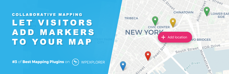
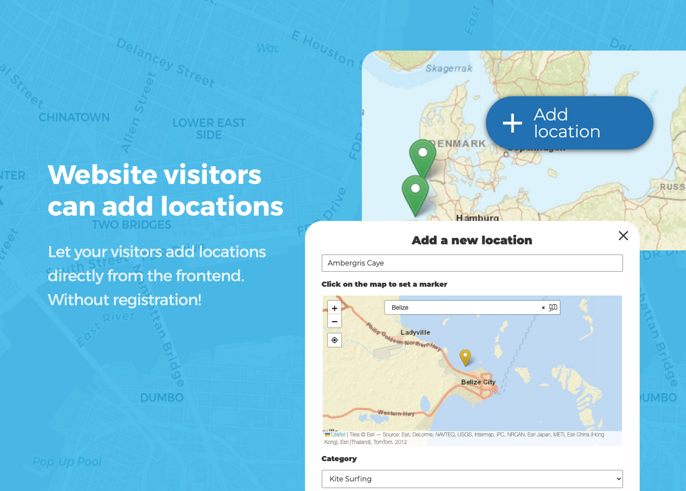
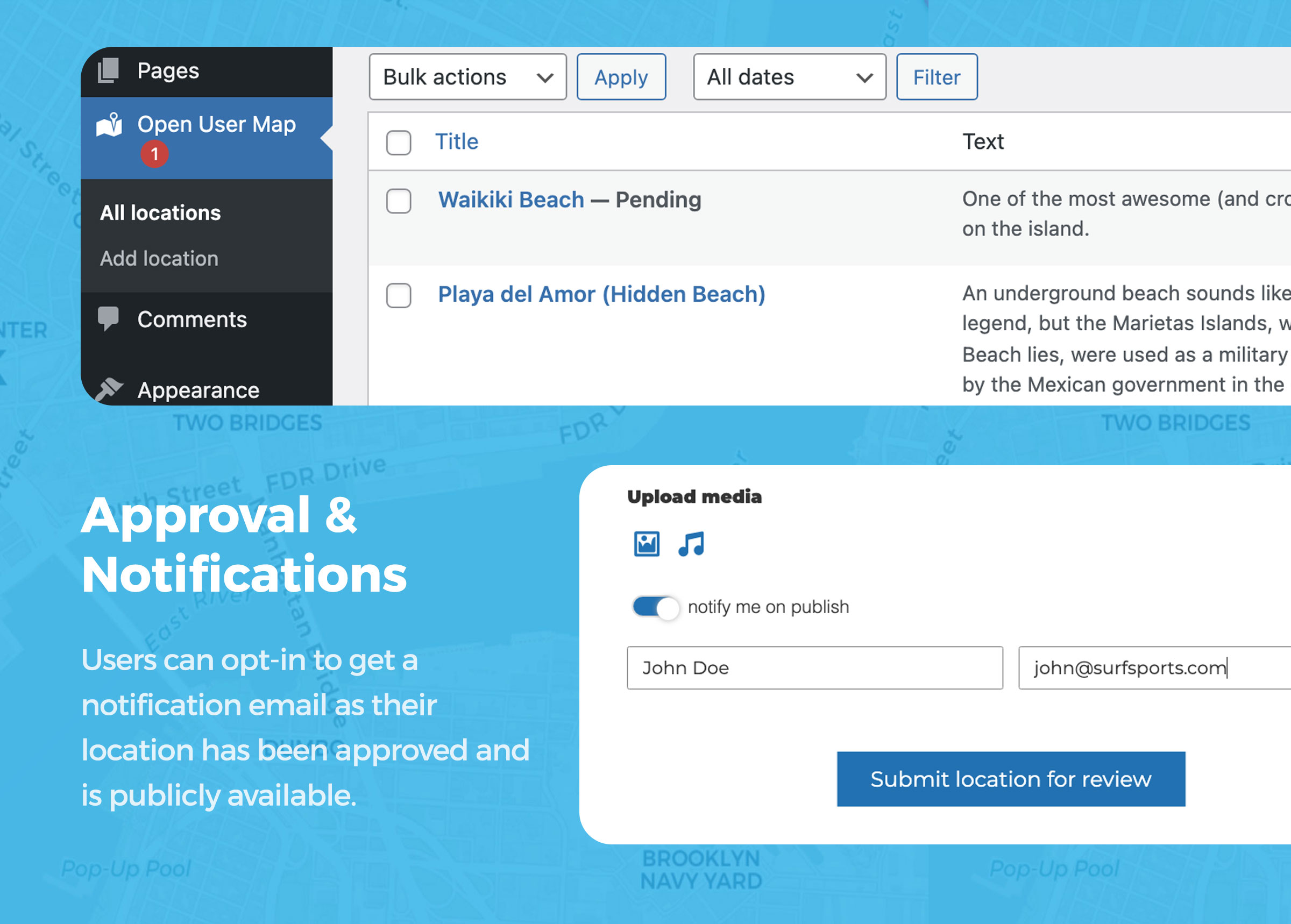
Du kannst eigene Marker hinzufügen — oder Website-Besucher neue Marker direkt im Frontend einreichen lassen. Neue Einreichungen können auf deine Freigabe warten, bevor sie auf der Karte erscheinen, sodass du die volle Kontrolle behältst.
Es ist kein Google Maps-API-Schlüssel erforderlich. Open User Map basiert auf Leaflet Map JS und bietet kostenlose, auf OpenStreetMap und MapBox basierende Kartenstile, Marker-Icons, Suchfunktionen sowie flexible Einbettungsoptionen für Gutenberg, Elementor und Shortcodes.
Möchtest du alle Premium-Funktionen testen? Starte die 7-tägige Open User Map PRO-Testversion — keine Kreditkarte erforderlich.
🚀 7-tägige PRO-Testversion starten (keine Kreditkarte) | 🔥 Live-Demos ansehen | 📖 Mehr erfahren | ❓ Hilfe
Was kannst du mit Open User Map erstellen?
📍 Eine einfache individuelle Karte – Zeige deine eigenen Marker auf einer schönen interaktiven Karte.
👥 Eine Community-Karte – Lasse Besucher neue Marker direkt im Frontend hinzufügen.
✅ Eine moderierte Karte – Prüfe und genehmige neue Marker-Einreichungen vor der Veröffentlichung.
📡 Ein Store Locator – Präsentiere Marker für Unternehmen und hilf Besuchern, Orte in der Nähe zu finden.
🔎 Eine filterbare Verzeichnis-Karte – Organisiere Marker mit Kategorien, Suche und individuellen Feldern.
😎 Personalisierte Benutzerkarten – Zeige individuelle Karten für angemeldete Benutzer.
Warum Open User Map?
✅ Schöne interaktive Karten – Erstelle moderne Karten, die nicht wie langweilige Standard-Karteneinbettungen wirken.
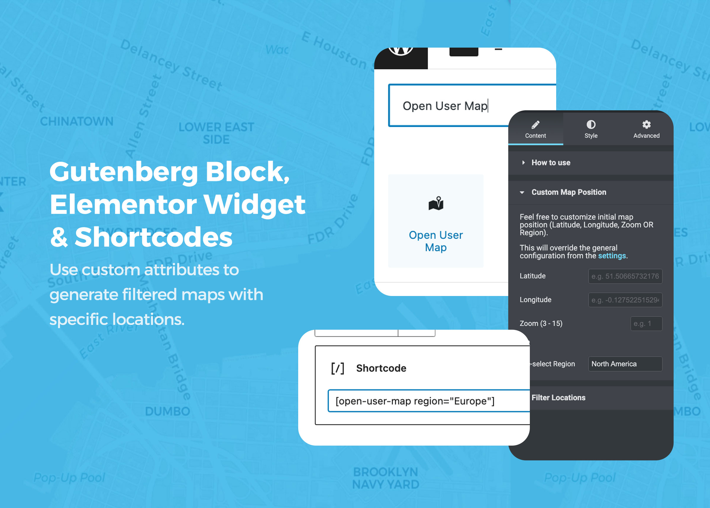
✅ Für WordPress gemacht – Bette Karten mit Gutenberg-Blöcken, Elementor-Widgets oder Shortcodes ein.
✅ Marker-Einreichungen im Frontend – Besucher können Pins ohne Backend-Zugriff hinzufügen.
✅ Freigabe-Workflow inklusive – Behalte die Kontrolle darüber, was veröffentlicht wird.
✅ Kein Google Maps API-Key erforderlich – Vermeide API-Einrichtung, Access Tokens und Google-Maps-Einschränkungen.
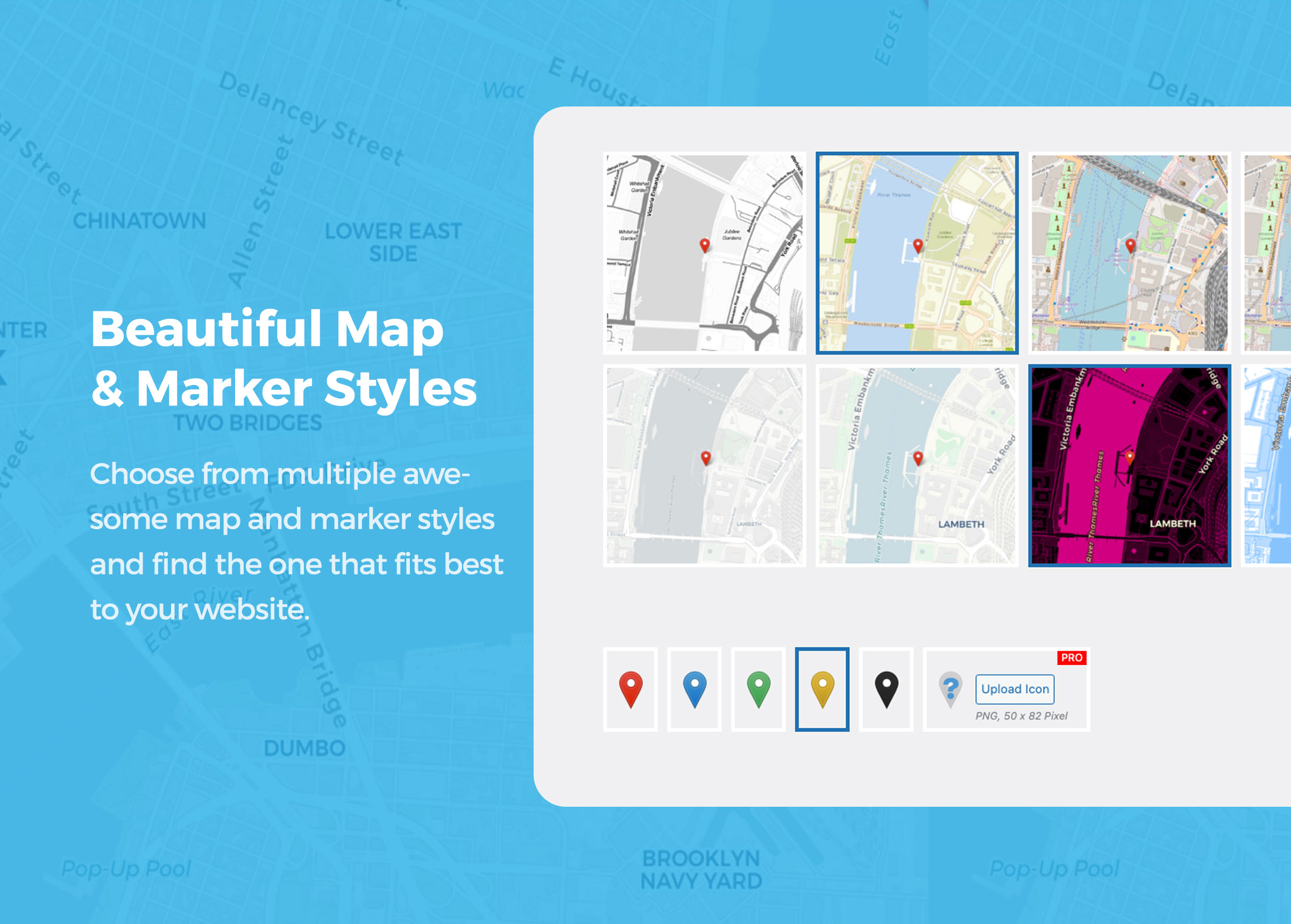
✅ Mehrere Kartenstile – Nutze OpenStreetMap, MapBox und andere flexible Kartenstile.
✅ Leistungsstarke Suchoptionen – Marker-Suche, Adresssuche und Kategorie-Filterung.
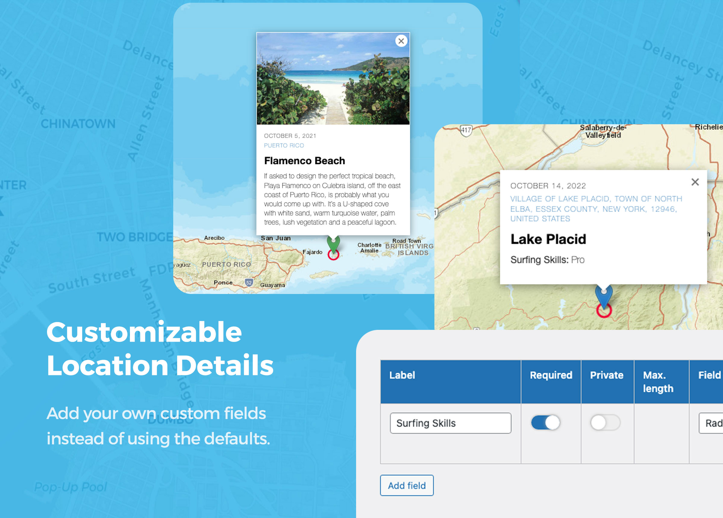
✅ Anpassbare Formulare & Felder – Sammle genau die Markerdaten, die du brauchst.
✅ Medienreiche Marker – Füge Beschreibungen, Bilder, Audio, Videos und mehr hinzu.
✅ Perfekt für Verzeichnisse, Community-Karten, Reiseblogs, Events, lokale Guides und Marker für Unternehmen.
Erstelle eine Karte in 1 Minute
🍿 Video auf YouTube ansehen: Was ist Open User Map?
🌏 Wie man eine einfache Karte erstellt
Erstelle eine klare, individuelle Karte, die nur deine eigenen Marker zeigt. Das ist perfekt für Marker für Unternehmen, Reiseziele, Veranstaltungsorte, Immobilienangebote oder jede andere Sammlung von Orten, die du auf deiner Website anzeigen möchtest.
Du kannst Besucher-Einreichungen deaktivieren und Open User Map als einfaches individuelles Karten-Plugin für WordPress verwenden.
🍿 Video auf YouTube ansehen: Wie man eine einfache Karte erstellt
👩🏾🚀🤵👩🏻🎤👩🏽🌾👩🏿💻 Wie man eine interaktive Karte erstellt
Erstelle eine Community-Karte, auf der Besucher neue Marker direkt im Frontend hinzufügen können. Du kannst Benachrichtigungen für neue Einreichungen erhalten und jeden Marker vor der Veröffentlichung freigeben.
Deine Besucher können weltweit nach Adressen oder bestehenden Markern suchen, um schnell den richtigen Ort zu finden. Du kannst individuelle Felder und Beschreibungen zum Einreichungsformular hinzufügen, um die benötigten Daten zu sammeln. Bild-, Video- und Audio-Uploads sind ebenfalls möglich.
Lasse deine Benutzer mitarbeiten und sieh zu, wie deine Karte wächst.
Wie deine Website-Besucher neue Marker zu deiner Karte hinzufügen:
Besucher klicken einfach auf den „+“-Button auf der Karte. Es öffnet sich ein Formular, in dem sie die Marker-Details bequem im Frontend eingeben können. Nach dem Absenden kann der neue Marker als „Ausstehend“ gespeichert werden und auf deine Prüfung warten, bevor er veröffentlicht wird.
🍿 Video auf YouTube ansehen: Einen neuen Marker hinzufügen
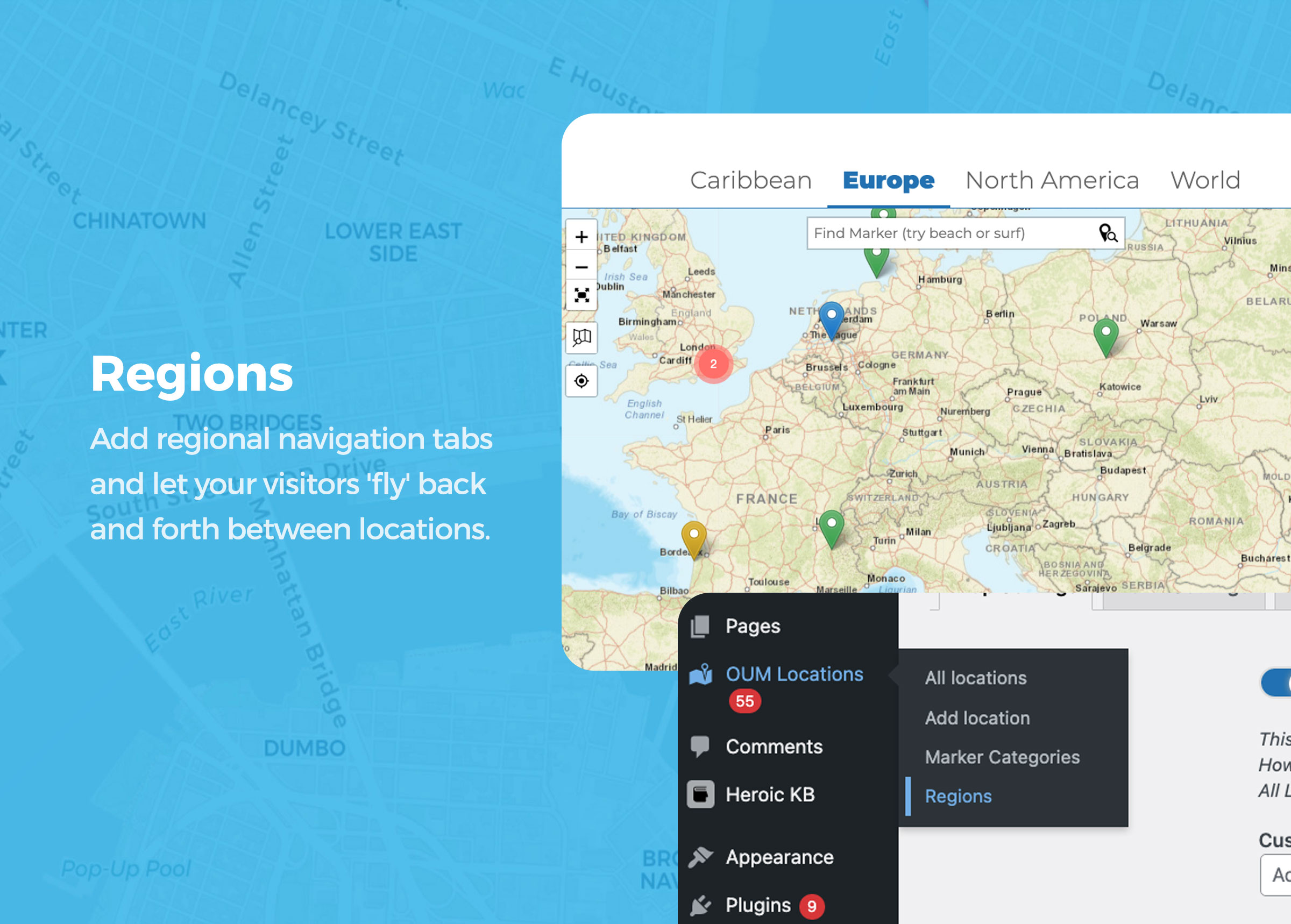
🆕 Regionen
Füge regionale Navigations-Tabs hinzu und lasse Besucher zwischen weit voneinander entfernten Orten hin- und herfliegen. Das ist nützlich für Karten, die mehrere Städte, Länder, Regionen oder große Gebiete abdecken.
Sieh dir die Demo-Karte an.
🍿 Video auf YouTube ansehen: Regionen
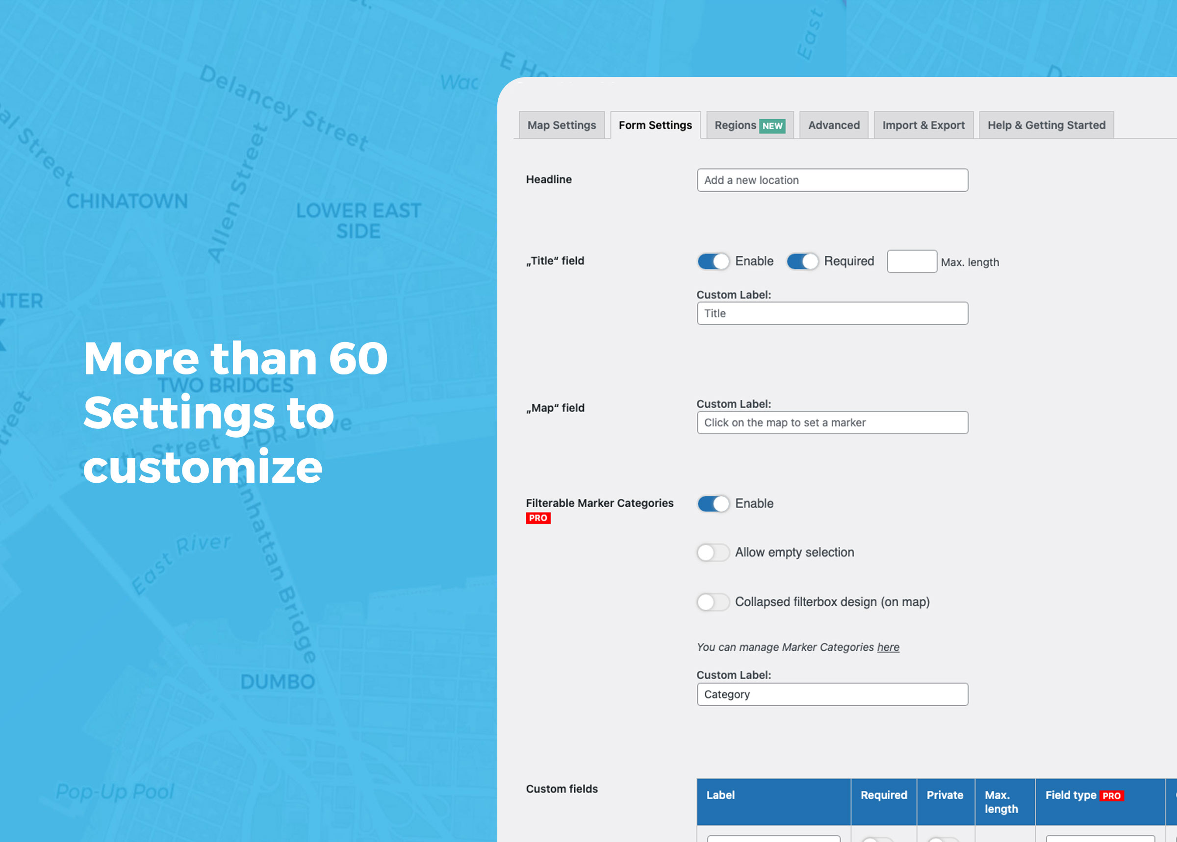
Mehr als 60 Optionen zum Anpassen
Verwende den Gutenberg-Block, das Elementor-Widget oder den Shortcode, um deine Karte überall auf deiner WordPress-Website einzubinden.
Nahe beieinanderliegende Marker können per Marker-Clustering gruppiert werden. Du kannst Kartengröße, Marker-Stile, Kartenfokus, Suchoptionen, Frontend-Formularfelder, Textlabels, Weiterleitungen, Dankesnachrichten und vieles mehr anpassen.
Individuelle Felder ermöglichen es dir, das Formular für Marker-Einreichungen genau an deinen Anwendungsfall anzupassen.
Kostenlose Features:
- Marker im Frontend hinzufügen (kann deaktiviert werden)
- Frontend-Bearbeitung von Standorten (für registrierte Benutzer)
- Admin-Freigabe für neue Locations
- basierend auf Leaflet
- keine API-Keys erforderlich
- mehrere Kartenstile (einschließlich MapBox)
- DSGVO-konforme Kartentiles mit Servern in Deutschland
- mehrere Markerstyles
- Regionen als Tabs 🆕
- Kartengröße in voller Breite
- Kartenfokus in fester Position halten (in einem Bereich bleiben)
- optionaler Scrollrad-Zoom 🆕
- Suche nach Markern 🆕
- Adresssuche mit OSM-Geosearch
- Adresse aus der Marker-Position automatisch per Reverse Geocoding erzeugen 🆕
- Locations mit benutzerdefinierten Feldern! 🥳
- private benutzerdefinierte Felder
- Marker nach benutzerdefinierten Feldern vorfiltern
- Marker nach Datum oder Zeitspanne vorfiltern
- Conditions (🪄 experimentell, siehe Abschnitt Hilfe)
- Die Felder „Untertitel“, „Beschreibung“, „Bild“, „Audio“ und sogar „Titel“ können deaktiviert werden
- Das „Untertitel“-Feld verlinkt auf die Google-Routenplanung
- jedes Textbit kann angepasst werden
- Standorte mit Bildern & Audio
- mehrere Bilder (Slider) pro Marker 🆕
- Shortcode mit benutzerdefinierten Einstellungen
- Gutenberg Block mit benutzerdefinierten Einstellungen
- Elementor Widget mit benutzerdefinierten Einstellungen
- Clustering von Markern
- Vollbildmodus
- Seite neu laden, Weiterleitung oder Dankesnachricht nach dem Absenden
- URL-Parameter &markerid=123 verwenden, um einen bestimmten Marker auf der Karte hervorzuheben
- einen bestimmten Wert eines Markers mit der PHP-Funktion oum_get_location_value( ‚DEIN WERT‘, $post_id ) abrufen
- Verwende WordPress-Hooks, um die Plugin-Funktionalität mit eigenem Code zu erweitern, einschließlich eines Hooks zum Ändern von Marker-Daten vor dem Rendern 🆕
- Nutze den Shortcode [open-user-map-form] um nur das Formular (ohne Karte) anzuzeigen
- Benutzerdefiniertes JS
- Benutzerdefiniertes CSS
🚀 PRO
Open User Map PRO gibt dir mehr Kontrolle, mehr Automatisierung und mehr Flexibilität für erweiterte Community-Karten, Verzeichnisse und professionelle Kartenprojekte.
Du kannst alle PRO-Funktionen 7 Tage lang testen — keine Kreditkarte erforderlich.
🔥 7-tägige PRO-Testversion starten (keine Kreditkarte erforderlich)
⭐️ Filterbare Marker-Kategorien
Organisiere Marker in mehreren filterbaren Marker-Gruppen. Jede Gruppenkategorie kann ein eigenes Marker-Icon haben und ist für Besucher zugänglich.
⭐️ Linien & Flächen
Füge Linien und Flächen als zusätzliche Markertypen hinzu. Besucher können Routen, Wege, Zonen oder Grenzen direkt auf der Karte zeichnen.
⭐️ Live-Marker-Filter
Nutze die Suchleiste, um Marker während der Eingabe zu filtern. Relevante Marker werden sofort auf der Karte angezeigt.
⭐️ Erweiterte Filteroberfläche
Erstelle eine Filter-Seitenleiste neben deiner Karte und lasse Besucher Marker nach beliebigen konfigurierten individuellen Feldern filtern. Du kannst außerdem eigene HTML-Inhaltsbereiche hinzufügen, um zusätzliche Informationen oder Branding anzuzeigen.
⭐️ Kartenstil mit eigenem Bild
Füge deiner Karte eine eigene Bildebene hinzu oder ersetze die Karte vollständig durch ein eigenes Bild, z. B. einen Grundriss, Veranstaltungsplan, Sitzplan oder eine Fantasy-Karte – inklusive Interaktionen, Clustering und Popups.
⭐️ Marker nach Benutzer oder Rolle vorfiltern
Verwende Shortcode-Attribute, um Marker nach aktuellem Benutzer, Benutzer-ID oder Rolle zu filtern. Das funktioniert für Karten, Listen und Galerien.
⭐️ Abstimmungsbutton für Marker
Füge einen anpassbaren Button für Likes, Upvotes oder Markierungen hinzu – mit flexiblen Privatsphäre-Einstellungen.
⭐️ Sternebewertung
Lasse Besucher Marker mit einem anpassbaren Sternebewertungssystem bewerten.
⭐️ Mehr individuelle Feldtypen
Füge individuelle Felder wie Links, Radiobuttons, Checkboxen, Dropdowns, Öffnungszeiten und HTML hinzu. Social-Media-Links können automatisch als Icons dargestellt werden.
⭐️ Zusätzliche Geosearch-Anbieter
Nutze zusätzliche Geosearch-Anbieter wie Geoapify, HERE und MapBox.
⭐️ Videos von YouTube & Vimeo
Verwende Videos statt Bilder, um jeden Marker hervorzuheben.
⭐️ Marker exportieren & importieren
Du hast bereits eine Liste von Orten, die du auf der Karte anzeigen möchtest? Nutze CSV-Export und -Import, um Marker einfacher hinzuzufügen, zu verschieben oder gesammelt zu bearbeiten.
⭐️ E-Mail-Benachrichtigung an Benutzer
Benachrichtige Benutzer per E-Mail, nachdem ihr Marker freigegeben wurde.
⭐️ E-Mail-Benachrichtigung an Admins
Sende Benachrichtigungen an eine Admin-E-Mail-Adresse, wenn neue Marker-Vorschläge eingereicht werden.
⭐️ Zapier-/Webhook-Integration
Löse einen externen Webhook aus, wenn Marker erstellt oder aktualisiert werden.
⭐️ Benutzerbeschränkung
Beschränke die Funktion „Marker hinzufügen“ auf registrierte Benutzer und leite Besucher zu deinem Registrierungsformular weiter.
⭐️ Automatisch veröffentlichen
Lasse registrierte Benutzer direkt ohne Admin-Freigabe veröffentlichen. Das kann auch für nicht registrierte Benutzer aktiviert werden.
⭐️ Benutzerregistrierung erweitern
Füge die Funktion „Marker hinzufügen“ zum WordPress-Registrierungsformular hinzu.
⭐️ Individuelle Dateigrößen
Passe die maximale Dateigröße für Bild- und Audio-Uploads an. Der Standardwert ist 10 MB.
⭐️ Individuelle Marker-Icons
Verwende deine eigenen individuellen Marker-Icons.
⭐️ Aktueller Standort
Füge einen Button hinzu, der die Karte zum aktuellen Standort des Besuchers bewegt.
⭐️ Sichtbare Marker begrenzen
Begrenze die auf einer Karte angezeigten Marker nach Marker-Kategorien oder Beitrags-IDs. So kannst du nur Marker eines bestimmten Typs anzeigen oder einen einzelnen Marker ausgeben. Das ist über die Block-Einstellungen oder per Shortcode-Attribut möglich.
⭐️ Einzelseiten für Marker
Standardmäßig haben Marker keine Einzelseiten. So wird verhindert, dass sehr viele Marker-Beiträge deine SEO negativ beeinflussen. Wenn du Markern mehr Inhalte hinzufügen möchtest, kannst du Einzelseiten in Open User Map PRO aktivieren.
⭐️ Standard-Template für Einzelseiten
Wenn Einzelseiten aktiviert sind, erhalten Marker automatisch ein Beitragsbild, einen Auszug und ein Standard-Content-Template. Du kannst Marker außerdem innerhalb von Query-Loop-Blöcken anzeigen, um eine eigene Listen- oder Rasteransicht zu erstellen.
⭐️ Shortcodes für einzelne Marker-Werte
Verwende den Shortcode [open-user-map-location value=“DEIN WERT“ post_id=“POST-ID (optional)“], um einen Wert eines Markers auszugeben. Das ist nützlich, wenn du Einzelseiten für Marker erstellst. Alle verfügbaren Werte findest du im Hilfebereich der Plugin-Einstellungen unter Open User Map > Einstellungen > Hilfe.
⭐️ Alle Marker-Bilder als Galerie anzeigen
Verwende den Shortcode [open-user-map-gallery], um eine Galerie aller Marker-Bilder anzuzeigen. Jedes Bild verlinkt auf den entsprechenden Marker auf der Karte.
⭐️ Alle Marker als Liste oder Raster anzeigen
Verwende den Shortcode [open-user-map-list], um alle Marker als Liste anzuzeigen. Alternativ kannst du native Query-Loop-Blöcke verwenden, um eine individuelle Liste oder ein Raster zu erstellen.
⭐️ Registrierten Benutzern erlauben, ihre Marker zu bearbeiten
Open User Map PRO erweitert die WordPress-Berechtigungen für den Backend-Zugriff. Wenn die Berechtigung der Benutzerrolle zugewiesen ist, können registrierte Benutzer ihre eigenen Marker direkt in der Karte lesen, bearbeiten und löschen.
🔥 7-tägige PRO-Testversion starten (keine Kreditkarte erforderlich)
Anwendungsfälle
🍕 Restaurant & Food Guides
Erstelle eine kollaborative Karte, auf der Besucher selbst Marker hinzufügen können. Das eignet sich ideal für Reiseblogs, Stadtführer, Bar-Karten, Restaurant-Guides oder lokale Empfehlungsplattformen.
Frage dein Publikum nach den besten Orten für Essen und Getränke. Erstelle Kategorien wie Essen, Drinks, Musik oder Nachtleben und lasse Besucher Marker direkt im Frontend setzen. Beobachte, wie deine Karte schnell wächst.
👭👬 Gemeinschaftsbildung
Erweitere das WordPress-Registrierungsformular um ein „Marker hinzufügen“-Feld. Neue Benutzer können einen Marker auf der Karte setzen, um ihren Standort zu teilen.
Nutze es, um eine Benutzerkarte zu erstellen und deinem Publikum zu helfen, miteinander in Kontakt zu treten.
📺 Videotour Karte
Erwecke Marker mit Videos zum Leben. Besucher können Marker erweitern, indem sie YouTube- oder Vimeo-Videos direkt auf der Karte einbetten.
Das kann eine Videotour durch ein Viertel, ein Restaurant-Rundgang, ein Stadtführer oder ein Highlight einer Kulturveranstaltung sein. Perfekt für Reiseblogs, Stadtführer und virtuelle Touren.
🎤🎸 Soundkarte
Erstelle eine Sound Map und lasse dein Publikum Audiodateien zu Markern hochladen.
Das ist nützlich, um Klanglandschaften in städtischen oder abgelegenen Gebieten zu dokumentieren, Field Recordings zu sammeln, Audio-Touren zu erstellen oder kreative kartenbasierte Projekte umzusetzen.
🎯 Branchen Übersicht
Liste Unternehmen auf einer Karte mit Kategorien, Filtern, Suche und individuellen Feldern.
🗺️ Veranstaltungs- oder Reisekarten
Zeige Tour-Marker, Sehenswürdigkeiten, Veranstaltungsorte, Routen oder empfohlene Orte.
🏠 Immobilienanzeigen
Zeige Immobilien mit Bildern, Videos, Beschreibungen und individuellen Details.
📍 Händlersuche
Erleichtere es Kunden, die Marker deiner Läden zu finden.
📖 Weitere Beispiele & Live-Demos ansehen
Die Möglichkeiten sind endlos. Wir sind sehr gespannt, was du mit Open User Map erstellst. Kontaktiere uns gerne, teile dein Projekt oder sende uns Funktionswünsche. Dieses Plugin wird kontinuierlich weiterentwickelt und dein Feedback hilft uns, es zu verbessern.
Screenshots
Blöcke
Dieses Plugin bietet 1 Block.
- Open User Map Insert a custom map featuring your own locations or an interactive map where anyone can add location pins without registering.
Installation
Aus der WordPress Werkzeugleiste
- Plugins besuchen > Neu hinzufügen
- Suche nach „Open User Map“
- Installiere und aktiviere Open User Map von deiner Plugins-Seite aus
- Verwende den WordPress-Editor oder Elementor, um den Block „Open User Map“ in eine Seite einzufügen. Alternativ kannst du auch den Shortcode
[open-user-map]verwenden. - Du kannst Marker im Menü „Open User Map“ verwalten.
- Du kannst Design und Funktionen unter „Open User Map > Einstellungen“ verwalten.
FAQ
-
Benötige ich Google Maps oder einen Google Maps API-Schlüssel?
-
Nein. Open User Map ist ein WordPress-Karten-Plugin auf Basis von Leaflet, OpenStreetMap und MapBox-basierten Kartenstilen. Sie können individuelle interaktive Karten erstellen, ohne einen Google Maps API-Schlüssel einzurichten.
-
Kann ich eine individuelle Karte mit Leaflet-, OpenStreetMap- oder MapBox-Stilen erstellen?
-
Ja. Open User Map enthält kostenlose Leaflet-basierte Kartenstile und unterstützt Stile auf Basis von OpenStreetMap und MapBox. Sie können es als einfaches individuelles Karten-Plugin oder als interaktive Community-Karte verwenden.
-
Können Besucher Marker über das Frontend einreichen?
-
Ja. Website-Besucher können neue Marker oder Standort-Einreichungen direkt im Frontend hinzufügen. Sie können Frontend-Marker-Einreichungen in den Einstellungen aktivieren oder deaktivieren.
-
Kann ich Marker-Einreichungen freigeben, bevor sie auf der Karte erscheinen?
-
Ja. Neue Marker-Einreichungen aus dem Frontend können vor der Veröffentlichung auf Ihre Freigabe warten. Dadurch eignet sich Open User Map für moderierte Community-Karten, Verzeichnisse und kollaborative Projekte.
-
Kann ich eine einfache individuelle Karte ohne Besucher-Einreichungen erstellen?
-
Ja. Sie können Frontend-Einreichungen deaktivieren und Open User Map als einfache individuelle Karte verwenden, um eigene Marker, Marker für Unternehmen, Reiseziele, Veranstaltungsorte oder andere Marker anzuzeigen.
-
Kann ich meiner Karte Marker-Suche, Adresssuche und Filter hinzufügen?
-
Ja. Open User Map unterstützt Marker-Suche, Adresssuche und Filteroptionen. So helfen Sie Besuchern, Marker auf der Karte zu finden, und organisieren Marker mit Kategorien und benutzerdefinierten Feldern.
-
Kann ich Marker-Kategorien verwenden oder Marker nach Kategorie filtern?
-
Ja. Marker-Kategorien können verwendet werden, um Standorte zu gruppieren, zu gestalten und zu filtern. In Open User Map PRO können Marker-Kategorien außerdem eigene Icons und erweiterte Filteroptionen haben.
-
Kann ich die Karte mit Gutenberg, Elementor oder einem Shortcode einbetten?
-
Ja. Verwenden Sie den WordPress Block-Editor, das Elementor-Widget oder den Shortcode
[open-user-map], um Ihre Karte einzubetten. Sie können den Shortcode auch mit PHP in einem Theme-Template verwenden:echo do_shortcode("[open-user-map]") -
Kann ich einen Store Locator, ein Branchenverzeichnis oder eine Community-Karte erstellen?
-
Ja. Open User Map kann für Store Locator, Branchenverzeichnisse, Community-Karten, Reisekarten, Event-Karten, Immobilienkarten und andere Projekte rund um Marker verwendet werden.
-
Kann ich Kartenmarker importieren oder exportieren?
-
Ja. Open User Map PRO enthält CSV-Import und -Export für Marker. Das ist nützlich, wenn Sie bereits eine Liste von Orten haben, Marker gesammelt bearbeiten oder Markerdaten migrieren möchten.
-
Kann ich nur bestimmte Marker, Kategorien oder Standorte anzeigen?
-
Ja. Sie können sichtbare Marker nach Marker-Kategorien, Beitrags-IDs und Shortcode-Attributen einschränken. Das ist nützlich, um unterschiedliche Karten, Verzeichnisbereiche oder Markergruppen auf verschiedenen Seiten anzuzeigen.
-
Können Benutzer Bilder, Audio oder Videos zu Markern hochladen?
-
Ja. Marker können Beschreibungen, Bilder und Audio enthalten. Open User Map PRO unterstützt zusätzlich Videos von YouTube und Vimeo sowie weitere Medien- und Feldoptionen.
-
Können registrierte Benutzer ihre eigenen Standorte bearbeiten oder löschen?
-
Ja. Open User Map unterstützt die Bearbeitung im Frontend für registrierte Benutzer. Abhängig von Ihren Einstellungen und Berechtigungen können Benutzer ihre selbst eingereichten Marker bearbeiten oder löschen.
-
Kann ich den aktuellen Standort des Besuchers auf der Karte anzeigen?
-
Ja. Sie können eine Schaltfläche für den aktuellen Standort aktivieren, damit Besucher die Karte auf ihre eigene Position verschieben können. Das ist nützlich für lokale Karten, Orte in der Nähe, Verzeichnisse und Store-Locator-Anwendungsfälle.
-
Kann ich Marker-Icons, Farben und Kartenstile anpassen?
-
Ja. Open User Map enthält mehrere Marker-Stile, Kartenstile und Optionen für die UI-Farbe. Open User Map PRO ergänzt benutzerdefinierte Marker-Icons und zusätzliche Styling-Optionen.
-
Kann ich benutzerdefinierte Felder und Entwickler-Hooks verwenden?
-
Ja. Sie können benutzerdefinierte Felder hinzufügen, um genau die Markerdaten zu erfassen, die Sie benötigen. Entwickler können außerdem WordPress-Hooks, eigenes CSS und eigenes JavaScript verwenden, um die Kartenausgabe anzupassen.
-
Wo finde ich Hilfe oder wo kann ich Sicherheitslücken melden?
-
Bitte lesen Sie unsere Knowledge Base und durchsuchen Sie das Support-Forum. Sicherheitslücken können über das Patchstack Vulnerability Disclosure Program gemeldet werden.
Rezensionen
Mitwirkende und Entwickler
„Open User Map – Interactive Leaflet Maps“ ist Open-Source-Software. Folgende Menschen haben an diesem Plugin mitgewirkt:
Mitwirkende„Open User Map – Interactive Leaflet Maps“ wurde in 3 Sprachen übersetzt. Danke an die Übersetzer für ihre Mitwirkung.
Übersetze „Open User Map – Interactive Leaflet Maps“ in deine Sprache.
Interessiert an der Entwicklung?
Durchstöbere den Code, sieh dir das SVN-Repository an oder abonniere das Entwicklungsprotokoll per RSS.
Änderungsprotokoll
1.4.43
- Übersetzungen ins Französische und Spanische hinzugefügt
1.4.42
- NEU: Linien & Flächen als zusätzliche Markertypen
- Verbessert: Shortcode-Attribut für Listenpaginierung
- Verbessert: dashicons.css nur bei Bedarf laden
- Verbessert: RTL-Unterstützung
- Fehlerbehebung: Bildupload schlägt fehl, wenn die Dateigröße zu groß ist
- Fehlerbehebung: Inaktives Formular „Marker hinzufügen“
1.4.41
- Fehlerbehebung: Caching-Probleme beim Laden von Markerdaten
1.4.40
- Fehlerbehebung: Stimmen/Bewertungen wurden beim Aktualisieren eines Markers im Backend zurückgesetzt
- Fehlerbehebung: Bild-Slider im Marker-Popup fehlte
1.4.39
- Fehlerbehebung: Fehlende Marker bei aktiviertem Marker-Clustering
- Fehlerbehebung: Private individuelle Felder erscheinen beim Bearbeiten leer
- Verbessert: Einstellungen für Marker-Einreichungen
1.4.38
- Verbessert: Bessere Performance durch Lazy Loading für Marker-Popups
1.4.37
- Verbessert: Schriftgröße in den Geosearch-Ergebnissen
- Verbessert: Bessere Performance durch Lazy Loading für Marker-Popups
- Freemius-SDK-Update
1.4.36
- Fehlerbehebung: Schnelleres Batch Loading schlug bei einzelnen Markern fehl
1.4.35
- Verbessert: Größerer Cluster-Radius
- Verbessert: Bereinigung von Koordinaten beim Import
- Verbessert: Schnelleres Batch Loading für Marker
1.4.34
- NEU: Einstellung zum Deaktivieren von Marker-Popups
- Verbessert: Kompatibilität mit Lazy Loading
1.4.33
- Verbessert: Kompatibilität mit Lazy Loading
1.4.32
- Fehlerbehebung: Beitragstyp „Marker“ für Elementor zugänglich gemacht
- Verbessert: Sicherheit
1.4.31
- Verbessert: Der Workflow für automatisches Veröffentlichen ist jetzt konsistent: Admins veröffentlichen immer automatisch, andere Rollen hängen von „Registrierte Benutzer können Marker ohne Freigabe hinzufügen“ ab (Standard: aus)
- Verbessert: Rewrite Rules werden beim Umschalten des Einzelseiten-Modus aktualisiert, damit Marker-Permalinks sofort greifen
- Verbessert: Individuelle Zoomstufen pro Marker speichern
- Verbessert: Schneller Zoom für Karten in den Einstellungen
- Verbessert: Assistent und Einstellungsoberfläche
1.4.30
- NEU: Listen nach Titel, Datum oder individuellen Feldern sortieren (Shortcode-Attribut)
- Verbessert: Umgang mit Output-Buffer-Verbesserungen (automatischer Opt-out für OUM-Ausgaben)
- Verbessert: CSV-Exporte in Chunks ermöglichen jetzt die Verarbeitung sehr großer Datenmengen
- Verbessert: Kompatibilität mit dem Complianz-Plugin
- Verbessert: Markersuche im Dashboard
- Fehlerbehebung: JS-Absturz verhindert, wenn der Vollbild-Popup-Container fehlt
- Fehlerbehebung: JS-Absturz verhindert, wenn das Kartenelement bei der Loader-Initialisierung fehlt
- Fehlerbehebung: Fatalen Fehler verhindert, wenn die mbstring-Erweiterung nicht verfügbar ist
- Fehlerbehebung: Vote-AJAX-Warnungen bei fehlerhaften Anfragen verhindert
- Fehlerbehebung: Absturz des Öffnungszeiten-Parsers bei unerwarteten Feldnamen verhindert
- Fehlerbehebung: Nicht verfügbare WordPress-Upload-Verzeichnisse in Upload-Abläufen abgefangen
- Fehlerbehebung: Defensive DOM-Prüfungen für Frontend-Formular und Backend-Einstellungen hinzugefügt
- Fehlerbehebung: Abstürze beim CSV-Import verhindert, wenn Datei-Handles nicht geöffnet werden können
- Fehlerbehebung: CSV-Import gegen fehlerhafte und leere Zeilen abgesichert
1.4.29
- Temporäre Korrektur: Manueller Opt-in für die Verarbeitung von Output-Buffering-Ebenen
1.4.28
- Änderungen am Umgang mit Output-Buffering-Ebenen zurückgenommen (1.4.25 und 1.4.26)
1.4.27
- Fehlerbehebung: Website-Layout stürzte nach dem Update auf Version 1.4.26 ab
1.4.26
- Fehlerbehebung: Website-Absturz bei Plugin-Aktivierung verhindert, wenn die Freemius-Initialisierung fehlschlägt (z. B. abgelaufene Lizenzen, Wiederherstellungsmodus)
- Verbessert: Kompatibilität mit Themes, die Output-Buffering-Ebenen hinzufügen
1.4.25
- Verbessert: Anpassung des Rewrite-Slugs ermöglicht (fehlerhaft in 1.4.24)
1.4.24
- Fehlerbehebung: Plugin stürzt bei Aktivierung ab (in seltenen Fällen)
- Verbessert: Debug-Info (Einstellungen > Hilfe & Erste Schritte > Debug-Info)
1.4.23
- NEU: Individueller Feldtyp „Öffnungszeiten“
- NEU: Sternebewertung
- NEU: Adresse automatisch aus der Marker-Position erzeugen (Reverse Geocoding)
- NEU: Hook zum Ändern von Marker-Daten vor dem Rendern
- Fehlerbehebung: Admin-Benachrichtigung bei neuen Marker-Vorschlägen
- Fehlerbehebung: Elementor beschädigt den Video-Player
- Fehlerbehebung: Schwerwiegende Probleme mit Elementors Element Cache
- Verbessert: Beitragstyp „Marker“ ist jetzt standardmäßig in Elementor verfügbar
- Verbessert: Block-Stil im Elementor-Editor
- Verbessert: „Bearbeiten“-Button ist jetzt cache-unabhängig
1.4.22
- NEU: Visueller Editor zum Positionieren eines eigenen Overlay-Bildes auf der Karte
- Verbessert: Kartenfokus an fester Position halten
- Fehlerbehebung: Sicherstellen, dass individuelles JS in allen Umgebungen geladen wird
1.4.21
- Verbessert: Stil des Marker-Popups
- Verbessert: Seitenverhältnis der Formular-Karte
- Fehlerbehebung: Admin-Benachrichtigung bei Auto-Draft
- Fehlerbehebung: Platzhalter für Query-Filter in Bricks Builder
1.4.20
- Verbessert: Neue CSV-Import-Einstellung: Importierte Marker sofort veröffentlichen
- Verbessert: Beim Speichern im aktiven Einstellungs-Tab bleiben
- Verbessert: Update-Hinweis
- Verbessert: Aktuelle Version in den Einstellungen anzeigen
- Verbessert: Hinweis „Erste Schritte“
- Fehlerbehebung: Beschriftung individueller Felder als „erforderlich“ markieren
1.4.19
- Verbessert: Formularstile
- Verbessert: Composer-Autoload durch eigene Lösung ersetzt
- Verbessert: AND/OR-Beziehung für Checkbox-Filter einstellbar gemacht (erweiterte Filteroberfläche)
- Fehlerbehebung: Individuelles CSS wurde nicht geladen
1.4.18
- Fehlerbehebung: CSS wurde in seltenen Fällen nicht geladen
1.4.17
- Verbessert: Webhook-Daten
- Verbessert: Initiale Kartenposition
- Verbessert: Schriftstile
- Sicherheitsfix
1.4.16
- NEU: Neuer Kartenstil: Eigenes Bild [PRO]
- NEU: Erweiterte Filteroberfläche [PRO]
- NEU: Neues Shortcode-Attribut zum Filtern nach individuellen Feldern
- NEU: Neues Shortcode-Attribut zum Filtern nach Datum
- NEU: Erweiterte Einstellungen > Feld für individuelles CSS
- Verbessert: data-custom-field-label zum Wrapper individueller Felder hinzugefügt, für bessere CSS-Anpassungen
- Verbessert: Automatisches Veröffentlichen für registrierte Benutzer standardmäßig aktiviert
- Verbessert: Mehrfachauswahl in individuellen Feldern vom Typ „select“ ermöglicht
- Verbessert: Funktion oumConditionalField()
- Verbessert: Sichtbare Beschriftungen zu allen Formularfeldern hinzugefügt
- Verbessert: Karten-Einstellungen: kleinere Zoom-Schritte
- Verbessert: JSON-Ausgabe für den Shortcode [open-user-map-location] ermöglicht
- Verbessert: Bessere UX für Code-Snippets (Hilfebereich)
- Verbessert: JS-API-Dokumentation zu Hilfe & Erste Schritte hinzugefügt
- Verbessert: Freemius-SDK-Update
- Fehlerbehebung: Kompatibilität mit Borlabs Cookie Content Blocker
- Fehlerbehebung: Umbenennung des Feldes „address“ in „subtitle“ (CSV & Doku)
- Fehlerbehebung: Eigener Kartenstil beim Kartenwert eines Markers
- Fehlerbehebung: Bereinigung von Link-Feldern
- Fehlerbehebung: Falsche Nonce
- Fehlerbehebung: Flexbox-Problem im Elementor-Widget (standardmäßig keine Breite gesetzt)
- WordPress-6.9-Kompatibilität
1.4.15
- Sicherheitsfix
1.4.14
- Stilverbesserungen
1.4.13
- Neu: Shortcode [open-user-map-form] verwenden, um das Formular „Marker hinzufügen“ eigenständig ohne Karte anzuzeigen
- Neu: Kategorie-Icons im Formular anzeigen
- Neu: Kategorie-Icons neben dem Marker-Titel anzeigen (optional)
- Neu: Text des Buttons „Schließen und Karte aktualisieren“ anpassen
- Korrektur: PHP-Hinweis
- Freemius-SDK-Update
1.4.12
- Neu: „Alle auswählen“-Umschalter für Kategorien
- Korrektur: Erforderlich-Option für individuellen Feldtyp „Select“ ist fehlerhaft
- Korrektur: Erforderliches Bild-Upload-Feld ist beim Bearbeiten ungültig, obwohl bereits ein Bild existiert
- Korrektur: <-Symbol wird aus dem individuellen Textfeld entfernt
- Korrektur: oum_get_vote_count (admin_ajax) benötigt zu viel Ladezeit (Listenansicht)
- Korrektur: YouTube-URLs fehlen im CSV-Export
- Korrektur: Navigationsbereiche des Karussells
- Korrektur: Serverfehler, wenn die Funktion error_log deaktiviert ist
- Korrektur: Stimmenanzahl wird beim Bearbeiten zurückgesetzt
- Neu: Hook zum Anpassen des Standard-Templates für Einzelmarker-Inhalte
- Sicherheitsverbesserungen
1.4.11
- Fehlerbehebung: Einstellung für Standard-Marker-Icon wurde ignoriert
- Neue PRO-Funktion: Abstimmungsbutton (Like, Upvote, Markieren, …) für Marker
1.4.10
- Neu: Shortcode-Option types-relation=“AND“, um nur Marker anzuzeigen, die allen ausgewählten Kategorien entsprechen
- Neu: Spezial-Icon für Marker mit mehreren Kategorien (anpassbar)
- Korrektur: Beitragsbilder wurden dupliziert statt wiederverwendet, wenn ein bestehendes Bild ausgewählt wurde
1.4.9
- Saubere UTF-8-Kodierung für Marker-Daten (repariert Daten bei Bedarf)
- Hilfebereich aktualisiert: oum_get_location_value(‚images‘) statt oum_get_location_value(‚image‘) verwenden
- Testversion in den Einstellungen bewerben (neuer Tab „Kostenlose Testversion starten“)
- Textdomain früher laden (init mit Prio 1)
- Freemius-SDK-Update
1.4.8
- 🚀 Performance-Boost: Attachment-IDs der Mediathek vorladen
1.4.7
- Deutsche Übersetzungen an die PRO-Version angehängt
- Fehlerbehebung: JS-Fehler bei fehlgeschlagener Karteninitialisierung verhindert
- Fehlerbehebung: CSV-Import für Multisite-Setups
- Backend-Stilkorrekturen
- Freemius-SDK-Update
1.4.6
- Neu Setting: Number of possible Bild-Uploads (1-5)
- Aktuellen Benutzer Markern zuweisen, die noch nicht zugeordnet sind (bei Freigabe)
- Stilkorrektur: Weiterlesen
- Fehlerbehebung: PHP-Hinweis (_load_textdomain_just_in_time)
- Fehlerbehebung: PHP-Warnung bei leerem Marker-Array
1.4.5
- WordPress-6.8-Kompatibilität
- Individuellen Karten-Zoom für jeden Marker festlegen
- Farbeinstellung für UI-Elemente ist jetzt in der kostenlosen Version verfügbar
- „post_id“ zum Webhook-Payload hinzufügen
- Neu option: Bild Size in Popup (Original or Cover with Aspect Ratio)
- Fehlerbehebung: Automatische Vorschläge der Marker-Suche
- Fehlerbehebung: Zugewiesenes Marker-Kategorie-Icon für [open-user-map-location value=“map“] verwenden
- Fehlerbehebung: Aktueller Standort
1.4.4
- Button „Marker löschen“ durch die Berechtigung „delete_oum-locations“ beschränken
- Fehlerbehebung: Doppelter Website-Pfad in Bild-URLs (nur bei Multisite mit Ordner)
- Fehlerbehebung: YouTube-Video spielt nach dem Schließen des Markers weiter (mobil)
- Fehlerbehebung: Bearbeiten-Icon auf dem iPhone nicht klickbar
1.4.3
- Fehlerbehebung: Automatische Erstellung von Beitragsbild und Auszug
- _blank-Ziel aus individuellem Feld-Link entfernen
- Bilder immer als relative Pfade speichern
- Sicherstellen, dass site_urls mit Ordner mit relativen Bildern funktionieren
- PRO: Shortcode-Attribut zum Filtern von Markern nach aktuellem Benutzer, user_id oder Rolle
1.4.2
- Fehlerbehebung: „Marker hinzufügen“ schlug ohne Bild-Upload-Feld fehl
- Fehlerbehebung: Beschriftung „Medien hochladen“ fehlte
- Fehlerbehebung: „Beschriftung als Linktext verwenden“ funktionierte in der Listenansicht nicht
- Verhindern, dass Inline-JS von Caching- und Pagespeed-Plugins verarbeitet wird
1.4.1
- Fehlerbehebung: Nach Beitrags-IDs filtern
- Fehlerbehebung: Reihenfolge individueller Felder nicht korrekt (Frontend)
- Fehlerbehebung: Keine Fehlermeldung beim Hinzufügen zu großer Bilder
- Funktionswunsch: %user_email% und %user_name% in der Admin-Benachrichtigungs-E-Mail
- Freemius-SDK-Update
1.4.0
- Funktionswunsch: Mehrere Bilder (Karussell) pro Marker 🥳🥳🥳
- Komplette JS-Umstrukturierung für bessere Performance und Skalierbarkeit
- Performance-Boost: Anzahl der DB-Abfragen um 80 % reduziert
- Performance-Boost: Bessere Verarbeitung großer Mengen individueller Felder
- Neuer Bildgalerie-Stil
- Einstellungsoberfläche optimiert
- Template für Einzelmarker optimiert
- ID-Spalte zur OUM-Marker-Tabelle hinzugefügt
- Optimierung der ARIA-Labels
- Freemius-SDK-Update
1.3.54
- Berechtigung „Marker bearbeiten“ zur Rolle „Abonnent“ hinzufügen
- Fehlerbehebung: Kompatibilitätsprobleme bei Verwendung des Shortcodes mit einigen Page Buildern
- Funktionswunsch: Neue Datumseinstellungen, um entweder Änderungsdatum oder Veröffentlichungsdatum anzuzeigen
1.3.53
- Fehlerbehebung: Gutenberg-Block-Buttons
- Fehlerbehebung: „Mobile Map Ratio“ wegen Inkompatibilität mit Elementors neuem „Container“-Element entfernt
1.3.52
- Globale Leaflet-Instanz beibehalten, um Konflikte mit anderen Plugins zu verhindern
1.3.51
- Fehlerbehebung: Listenansicht-Stil
- Fehlerbehebung: Eingabestil der Marker-Suche
- Fehlerbehebung: Video-Stil
- Funktionswunsch: Webhook bei neuen oder aktualisierten Markern auslösen
1.3.50
- Dieses Release priorisiert Funktionswünsche im Zusammenhang mit der Flutkatastrophe in Spanien
- 🎉 Funktionswunsch: Suchleiste zum Live-Filtern von Markern (PRO)
- Funktionswunsch: Template-Overrides ermöglichen
- Fehlerbehebung: Beim Bearbeiten eines Markers gehen Bild/Audio verloren
- Fehlerbehebung: Bedingungen für den Button „Marker bearbeiten“
- Funktion oumConditionalField verbessert, um mehrere Event Listener zu akzeptieren
1.3.49
- Dieses Release priorisiert Funktionswünsche im Zusammenhang mit der Flutkatastrophe in Spanien
- Funktionswunsch: Benutzer können ihre eigenen Marker löschen
- Funktionswunsch: Backend-Suche für Marker durchsucht jetzt alle Felder
- Funktionswunsch: Änderungsdatum statt Erstellungsdatum anzeigen
- Bearbeitungsformular: „Neuen Marker hinzufügen“ –> „Marker bearbeiten“
1.3.48
- Dieses Release priorisiert Funktionswünsche im Zusammenhang mit der Flutkatastrophe in Spanien
- Funktionswunsch: Neue Icons (Achtung, In Bearbeitung, Erledigt, Haus, Person)
- Funktionswunsch: YouTube- & Vimeo-Videos zu einem Marker hinzufügen (PRO-Funktion)
- Schließen-Button für die Filterbox
- Bessere responsive Stile für die Filterbox
- WordPress-6.7-Kompatibilität sichergestellt
1.3.47
- Freemius-SDK-Update
1.3.46
- Fehlerbehebung: Mehrsprachige Marker werden nicht nach Sprache gefiltert
- Fehlerbehebung: Hinzufügen im Frontend
- Stiloptimierungen
- Marker-Slug zu durchsuchbaren Inhalten hinzugefügt (löst oe-/ö-Suchanfragen)
- Freemius-SDK-Update
1.3.45
- Fehlerbehebung: „Lokalisieren“-Button schlug fehl
- Fehlerbehebung: Position der Formular-Karte ist initial leicht verschoben
- Fehlerbehebung: Mapbox-Adresssuche schlug manchmal fehl
- Fehlerbehebung: Individuelles JS wird bei Simple Map nicht geladen
- Fehlerbehebung: Mapbox/HERE im Registrierungsformular verwenden
- Fehlerbehebung: Pflicht-Bildfeld bei der Frontend-Bearbeitung
- Fehlerbehebung: Bearbeiten-Icon auf dem iPhone nicht klickbar
- 🎉 Funktionswunsch: Registrierung: Beitragsautor setzen statt Feld „User ID“ (jetzt entfernt)
- Funktionswunsch: Feld wp_author_id in Export/Import
1.3.44
- 🎉 Funktionswunsch: Frontend-Bearbeitung! Angemeldete Benutzer können ihre Marker jetzt direkt in der Karte bearbeiten.
- Bessere Vollbild-Option (jetzt auch auf iOS verfügbar)
- Datenattribute für individuelle Felder (Listenansicht)
- Beschriftung statt Wert für individuelles Feld „Link“ verwenden (optional)
- Fehlerbehebung: Initialer Mindest-Zoom
- Freemius-SDK Update
1.3.43
- Fehlerbehebung: Import bricht bei leerer Zeile ab
- Fehlerbehebung: Schriftfarben im dunklen Theme
- Datenattribute zu individuellen Feldern hinzufügen
- Freemius-SDK Update
- WordPress-6.6-Kompatibilität sichergestellt
- Marker übersetzbar machen
1.3.42
- Fehlerbehebung: Filterbox nicht sichtbar
1.3.41
- Fehlerbehebung: Eingeklappte Filterbox auf Mobilgeräten
- Fehlerbehebung: Zeilenumbrüche in der Listenansicht
- Fehlerbehebung: Dropdown für Marker-Kategorien erscheint nicht
- Einstellungsseite optimiert
1.3.40
- Fehlerbehebung: Marker-Kategorie-Icons
- Styling der Marker-Kategorie-Box verbessert
1.3.39
- 🎉 Funktionswunsch: Marker-Kategorien können jetzt mehrfach ausgewählt werden (in den Einstellungen anpassbar)
- Dynamische Marker-Icon-Größe
- Mouseover-Animation für Marker-Icon
- Attribution des Kartentile-Anbieters hinzugefügt
- Freemius-SDK-Update
1.3.38
- Fehlerbehebung: Deutlich bessere JSON-Kodierung (soll Code-Unterbrechungen verhindern)
- Fehlerbehebung: Fehlschlagendes Shortcode-/Block-Rendering durch Slim SEO Plugin verhindert
- Stilkorrekturen
- Korrektur der Plugin-Version
1.3.36
- Fehlerbehebung: Listenansicht: Mehr als zwei Marker erlauben
- Fehlerbehebung: jQuery-Fehler auf Einzelmarker-Seiten
- 🎉 Standard-Template für Einzelmarker, wenn kein Inhalt oder individuelles Template festgelegt ist
- 🎉 Bessere Popup-Platzierung
- Marker-Bild bei Admin-Freigabe initial als Beitragsbild setzen
- Marker-Beschreibung bei Admin-Freigabe initial als Auszug setzen
1.3.35
- Hinweis „made with OUM“ entfernt
- Inkompatibilität (Bild-Upload) mit Plugin „Featured Image from URL (FIFU)“ behoben
- UI-Verbesserungen
1.3.34
- Fehlerbehebung: API-Key fehlt bei einzelner Karte mit Mapbox
- Funktionswunsch: Google-Routenlink mit Shortcode [open-user-map-location value=“route“ post_id=“12345″] abrufen
- Funktionswunsch: Shortcode, um alle Marker als Listenansicht auszugeben
- Funktionswunsch: Hook zum Anpassen der Ausgabe eines Marker-Listeneintrags
- Dateigrößen von Bildern reduziert (-75 %)
- Freemius-SDK Update
1.3.33
- Fehlerbehebung: CSV-Import-Validierung
- Freemius-SDK Update
1.3.32
- Fehlerbehebung: weißer Text auf weißem Hintergrund
- Eingabe des MapBox-API-Keys sicherstellen
- Gutenberg-Block: bessere UI
- Freemius Garbage Collector vorübergehend deaktiviert [Beta]
1.3.31
- Freemius-SDK-Update (inkl. Garbage Collector [Beta])
- Block: individuelle Einstellungen in die Einstellungen-Seitenleiste verschoben
- OUM-Attribution wieder aktiviert
- Abwärtskompatibilität von WordPress auf 5.5 gesetzt
1.3.30
- Fehlerbehebung: Testversions-Workflow
- OUM-Attribution deaktivieren
- WordPress-6.4-Kompatibilität sicherstellen
1.3.29
- Sicherstellen, dass Backend-Blockstile immer korrekt sind
- Fehlerbehebung: Testversions-Workflow
1.3.28
- Fehlerbehebung: PHP-Warnungen
- Fehlerbehebung: oumMap und oumMap2 in zusätzlichem JS nicht verfügbar
1.3.27
- Karte im Formular für JS-Anpassungen zugänglich machen (oumMap2)
- Sicherheitsverbesserung
1.3.26
- Fehlerbehebung: Testversions-Workflow
- Stadia-Kartenstil entfernt (automatischer Wechsel zu CartoDB Positron)
- Neue kommerzielle Kartenstile (MapBox)
- „MapBox“ als Geosearch-Anbieter-Option
- Stilprobleme behoben
1.3.25
- Funktionswunsch: Maximale Weltgrenzen leicht erweitert (Grüße nach NZ!)
- Funktionswunsch: Neuer Kartenstil: Satellit
- Fehlerbehebung: Kompatibilitätsproblem mit der Leaflet-Bibliothek von MapPress
- Fehlerbehebung: Kompatibilitätsproblem mit dem Complianz-Plugin
- Fehlerbehebung: Kompatibilitätsproblem mit der All In One SEO-Funktion „Run Shortcodes“
- Fehlerbehebung: Start-Längengrad 0
- Schrift-Reset für Textarea
- Umbenennung des Feldes „address“ in „Subtitle“
- Umbenennung von „bei Veröffentlichung benachrichtigen“ in „Benachrichtige mich, wenn es veröffentlicht ist“
- Umbenennung von „Adresse eingeben“ in „Nach Adresse suchen“
- Wording- & Sprach-Updates
1.3.24
- Wichtige Fehlerbehebung: falsches JS-Abhängigkeitsmanagement
- Leaflet-Providers-Bibliothek aktualisiert
- Kartenstil aktualisiert (Stamen > Stadia)
- neuer individueller Feldtyp „email“
- Individuelle Felder: Links in neuem Tab öffnen
- bessere Checkbox- & Radiobutton-Stile
- .pot-Datei für Übersetzungen aktualisiert
- Freemius-SDK-Update
1.3.23
- Fehlerbehebung: Assistent-Stil
1.3.22
- Menüpunkt „OUM Marker“ in „Open User Map“ umbenannt
- „Einstellungen“ nach „Open User Map > Einstellungen“ verschoben
- Wording
- Bewegen/Zoomen außerhalb der Haupt-Weltgrenzen verhindern
- Fehlerbehebung: Bubble-Bilder decken nicht vollständig ab (graue Ränder)
- Fehlerbehebung: Touchpad-Zoom zu langsam
1.3.21
- Fehlerbehebung: Karte im Formular verwendet individuelles Icon
- Geoapify & HERE als Geosearch-Anbieter
- Neues Shortcode-Attribut: map_type
- Neues Shortcode-Attribut: enable_cluster
- Neues Shortcode-Attribut: enable_fullscreen
- Neues Shortcode-Attribut: enable_searchbar
- Neues Shortcode-Attribut: enable_searchaddress_button
- Neues Shortcode-Attribut: enable_searchmarkers_button
- Neues Shortcode-Attribut: enable_currentlocation
- Neues Shortcode-Attribut: disable_regions
- Hinweis „made with OUM“ ausblenden (PRO)
1.3.20
- Attribution standardmäßig entfernen
- Assistent > Simple Map: Zusatzfunktionen (Suchleiste, Suchbuttons, Vollbild, aktuelle Position, Datum) standardmäßig deaktivieren
1.3.19
- Funktionswunsch: Neuer Hook zum Anpassen der Bildausgabe
- Fehlerbehebung: Direktlinks zu Markern
- neue Basisfarbe
- Stiloptimierungen
- Video-Tipp
1.3.18
- Fehlerbehebung: Lange CSV-Dateien schlugen beim Import fehl
- Fehlerbehebung: Assistent zeigt Schritt 3/3 nicht an
- Fehlerbehebung: Fehlende Marker bei Verwendung von Clustern (Konflikt mit Mindest-Zoom)
- Fehlerbehebung: Leerzeichen um Optionen individueller Felder entfernen/ignorieren
- Fehlerbehebung: HTML im Titelfeld verhindern (beschädigt JS)
- WordPress-6.3-Kompatibilität sichergestellt
1.3.17
- Fehlerbehebung: Apostroph im Marker-Namen
- Neue „How To“-Videos
1.3.16
- Bessere Einstellungen für „Kartentyp“
- Fehlerbehebung: Link zu „Manage your locations here“
1.3.15
- Fehlerbehebung: JS-Fehler beim Rendern von Marker-Details außer Karte
- Fehlerbehebung: Auf kleinen Bildschirmen verschob sich der Marker beim Schließen des Popups aus dem Sichtbereich
- Fehlerbehebung: Zoomstufen-Einstellung war auf max. 15 begrenzt
- Gutenberg-Block: individuelle Einstellungen weniger ablenkend gestaltet
- Freemius-SDK-Update auf 2.5.10
- Übersetzungen aktualisieren
1.3.14
- Inline-JS für das Complianz-Plugin auf die Whitelist gesetzt
- Feld für individuelles JS in den erweiterten Einstellungen
- Zoom bei markerid entspricht der Zoomstufe der Marker-Sucheinstellung
- Alphabetische Reihenfolge der Legende
- Fehlerbehebung: Ladezeiten durch externe Bilder
- Fehlerbehebung: Positionierung des Bubble-Inhalts beim Klick
- Fehlerbehebung: kein Standard-Icon für importierte Marker-Kategorien
- Fehlerbehebung: Vollbild-Anzeigeproblem
- Fehlerbehebung: fehlendes Bild-Thumbnail bei externen Bildern
1.3.13
- Wording (Umbenennung von „Type“ in „Marker Category“)
- Abonnenten für „Frontend-Hinzufügen nur für angemeldete Benutzer beschränken“ erlauben
- Besserer Marker-Zoom in der Bearbeitungsansicht
- Fehlerbehebung: Karte ist innerhalb eines Gutenberg-Akkordeons unvollständig
- Fehlerbehebung: Karte berücksichtigt fixierten Header nicht
- Fehlerbehebung: Inkompatibilität mit Avada Motion Effects
- Fehlerbehebung: Marker-Kategorie-Filter funktioniert bei einzelnen Markern pro Kategorie nicht korrekt
- Fehlerbehebung: Hinweis „Erste Schritte“ wird immer angezeigt
- Höhe ohne Einheit korrigiert
- Zeilenhöhe im Vollbild-Container des Markers korrigiert
1.3.12
- Funktionswunsch: Regionen und vorausgewählte Regionen
- Funktionswunsch: DSGVO-konformer Kartenstil (Server in Deutschland)
- Funktionswunsch: Karte im Formular soll dieselbe Ansicht wie die aktuelle Hauptkarte haben
- Funktionswunsch: Beschriftung neben Bild-/Audio-Upload-Buttons
- Funktionswunsch: Direktlink zum Marker-Backend in der Admin-Benachrichtigung
- Funktionswunsch: einstellbare Zoomstufe für die Marker-Suche
- Fehlerbehebung: Karte ist innerhalb eines Gutenberg-Akkordeons unvollständig
- Fehlerbehebung: Maximale Titellänge funktioniert nicht
- Freemius-SDK-Update (2.5.8)
- UI-Optimierungen
1.3.9
- Funktionswunsch: Beitragsbild für Einzelmarker-Seite erlauben
- Fehlerbehebung: Popups nicht im Vordergrund
- Fehlerbehebung: Marker verschwinden nach dem Upgrade auf 1.3.8
1.3.8
- Funktionswunsch: Text „Bei Veröffentlichung benachrichtigen“ anpassbar
- Funktionswunsch: Marker an aktueller Position setzen
- Funktionswunsch: Scrollrad-Zoom aktivieren (optional)
- Schnelleinrichtung korrigiert und optimiert
- Freemius-SDK-Update (2.5.7)
- Fehlerbehebung: automatisches Öffnen des Popups schlägt fehl
- Fehlerbehebung: Titelfeld kann nicht auf „nicht erforderlich“ gesetzt werden
- Fehlerbehebung: Import schlägt hinter Reverse Proxy fehl
1.3.7
- Funktionswunsch: Template für Einzelmarker ist jetzt im Website-Editor verfügbar
1.3.6
- Funktionswunsch: Marker-Bilder sollen immer von Jetpacks Lazy-Loading-Funktion ausgeschlossen werden
- Fehlerbehebung: PHP-Fehler bei fehlenden Benutzerrollen
- Fehlerbehebung: Bilder werden bei WordPress-Installationen in Unterverzeichnissen nicht geladen
- Freemius-SDK Update
1.3.5
- Fehlerbehebung: Farbe innerhalb der Marker-Info
1.3.4
- Funktionswunsch: Suche nach Markern
- Funktionswunsch: Bessere UI auf kleinen Bildschirmen
- Funktionswunsch: Tags für mehrere individuelle Feldwerte
- Funktionswunsch: IDs für Backend-Abschnitte
- Fehlerbehebung: Apostroph im Titel
- Fehlerbehebung: Fehlermeldung bei leerem individuellen Select-Feld
- Fehlerbehebung: SSL-bezogener Fehler (sehr langsames Laden der Seite)
- Fehlerbehebung: CSV auf WordPress Multisite importieren
- Fehlerbehebung: Name & E-Mail (Benachrichtigungsfunktion) sollen Pflichtfelder sein
- Fehlerbehebung: Hintergrundfarbe des Absenden-Buttons
- Freemius-SDK Update
- UI-Updates (Einstellungsseite)
- .pot-Update
1.3.2
- .pot-Datei für Übersetzung hinzufügen
- CSS-Resets
- Funktionswunsch: WordPress-Hooks (siehe Hilfebereich)
1.3.1
- Besserer Kartenfokus und Standard-Mindest-Zoom
- Update: Leaflet v1.9.3 und Add-ons
- Fehlerbehebung: Übersetzungs-Handling
- Funktionswunsch: Datumsinfo des Markers verwendet jetzt publish_date statt last_modified_date
1.3.0
- WordPress-6.1-Kompatibilität sichergestellt
- Menü „Open User Map“ in „OUM Marker“ umbenannt
- Assistent zur Ersteinrichtung hinzufügen
- Kartengröße & -höhe als Block-Attribute (Elementor, Gutenberg, Shortcode)
- Fehlerbehebung: Fehler abfangen, wenn die EXIF-PHP-Bibliothek fehlt
- Funktionswunsch: CSV-Import/-Export für Marker
- Experimentelle Funktion: Bedingte Felder per JS (siehe Hilfebereich)
1.2.26
- Fehlerbehebung: JS-Kommentare konnten Minifizierung durch Drittanbieter-Plugins beschädigen
- Fehlerbehebung: PHP-Warnung
- Feature: Elementor Widget
1.2.25
- Fehlerbehebung: Audio-Uploads deaktivieren funktioniert nicht
- Fehlerbehebung: Shortcode in Elementor führt zu JS-Fehler
- Design-Optimierung für Gutenberg-Block (im Editor-Modus)
- Chunked Loading für sehr viele Marker hinzufügen
1.2.24
- „Types“ in „Marker Categories“ umbenennen
- Plugin-Einstellungen refaktoriert und neu angeordnet
- Funktionswunsch: Marker-Datum anzeigen (optional)
- Funktionswunsch: Schließen-Button neu positionieren & bei Klick auf Hintergrund oder ESC schließen
- Funktionswunsch: Dropdown-Optionen für „Type“ entsprechen jetzt der Vorauswahl
- Fehlerbehebung: Vollbild funktioniert nicht
- Fehlerbehebung: PHP-Hinweis (undefined index)
1.2.23
- Overlay-Kompatibilität mit verschachtelten Seitenabschnitten sicherstellen
- FW: Option zum Erlauben leerer Typ-Auswahl
- Readme-Info: So exportierst du Marker
1.2.22
- Fehlerbehebung: Wert eines individuellen Feldes abrufen
1.2.21
- Funktion: Shortcodes für einzelne Marker-Werte
- Funktion: Archivseiten (wenn Einzelseiten aktiviert sind)
- Freemius-SDK-Update
1.2.20
- Fehlerbehebung: Karte global für Lazy-Loading-Trigger verfügbar machen (oumMap.invalidateSize() verwenden)
- Fehlerbehebung: Zitternde Karte bei fester Position
- Fehlerbehebung: Beitragstyp oum-location erscheint nicht in Elementor
- Fehlerbehebung: &-Symbol im Titel führt zu &
- Fehlerbehebung: `-Symbol in Titel oder Beschreibung beschädigt den Code
- Funktionswunsch: Adress-Suchleiste soll optional sein
- Galerie-Shortcode-Attribute hinzufügen (url, number)
1.2.19
- Fehlerbehebung: Audio-Upload auf dem iPhone
1.2.18
- Debug-Info unter Einstellungen > Open User Map > Hilfe hinzufügen
- Funktionswunsch: Kommentare für Einzelseiten erlauben
- Funktionswunsch: Individuelle Felder sollen eine Option „privat“ erhalten
- Funktionswunsch: individueller Mindest-Zoom, individuelle Kartengrenzen
- Funktionswunsch: m4a-Audioformat unterstützen
- Funktionswunsch: Adresssuchfeld auf der Karte
- Funktionswunsch: Shortcode [open-user-map-gallery], um alle Bilder als Galerie auszugeben
- Funktionswunsch: URL-Parameter &markerid=123 zum automatischen Öffnen eines bestimmten Markers
- Fehlerbehebung: automatisch zum Anfang des Formulars scrollen
1.2.17
- Fehlerbehebung: Probleme mit Output Buffer
- Fehlerbehebung: JS-Fehler bei deaktiviertem Audio-Upload
- Fehlerbehebung: falsches Bild-Thumbnail
- Funktionswunsch: neue Einstellung zum Einklappen des Filterbox-Designs (auf der Karte)
- Funktionswunsch: vollständiges Bild im Bearbeitungsbildschirm des Markers anzeigen
1.2.16
- Fehlerbehebung: Standard-Marker-Icon
- besseres Onboarding
- optimierter Backend-Stil
1.2.15
- Fehlerbehebung: Admin-Benachrichtigung schlug manchmal fehl
- Fehlerbehebung: Fehler bei fehlenden Standardrollen
- Funktionswunsch: Besseres „Zeig mir, wo ich bin“-Icon
1.2.14
- Fehlerbehebung: JS-Fehler im Backend (Color Picker & individuelle Felder)
- Fehlerbehebung: Im Backend hochgeladenes Bild hat kein Thumbnail
- Fehlerbehebung: Fehlende Bildrotation bei mobilen Uploads
- Funktionswunsch: Alle Texte sind jetzt anpassbar
- Funktionswunsch: Neues individuelles Feld „HTML“
- Funktionswunsch: Neue Berechtigungen, die registrierten Benutzern Bearbeitungszugriff ermöglichen
- Funktionswunsch: Entfernen-Button für Bild- & Audio-Uploads
- Funktionswunsch: Lade-Icon beim Absenden
- Optimiertes Einstellungs-Layout
- Code-Optimierung
1.2.13
- Fehlerbehebung: PHP-Warnung (type undefined)
- Funktionswunsch: Aktualisierung, Weiterleitung oder Textnachricht nach Validierung erlauben
- Funktionswunsch: Admin bei eingehenden Marker-Vorschlägen benachrichtigen
- Funktionswunsch: Button „Marker hinzufügen“ zum Registrierungsformular weiterleiten (wenn auf registrierte Benutzer beschränkt)
- Funktionswunsch: Zeichenanzahl in Textfeldern begrenzen
- Funktionswunsch: Leeren Optionswert erlauben
- Funktionswunsch: Automatisches Veröffentlichen für nicht registrierte Benutzer erlauben
1.2.12
- Fehlerbehebung: Styling von Checkboxen
- Fehlerbehebung: Kartenverschiebung beim ersten Klick auf Marker wegen Lazy-Loading-Bildmaßen falsch
- Funktionswunsch: neue Option zum automatischen Erzeugen eines Titels, um Marker ohne Titel zu ermöglichen
- Funktionswunsch: Titel des Formulars und der Buttons änderbar machen
- Funktionswunsch: Karte auf bestimmten Marker begrenzen
- Funktionswunsch: Karte auf bestimmten Typ begrenzen
- Funktionswunsch: einstellbare Kartenhöhe (Desktop & Mobil)
- FUNKTION: Gutenberg-Block mit Attributen anpassen
1.2.11
- Sicherheitsupdate
- Fehlerbehebung: „Bei Veröffentlichung benachrichtigen“ war nicht übersetzbar
- Funktionswunsch: mehrere Links (getrennt mit |)
- Funktionswunsch: Weitere Social-Media-Icons hinzufügen
- Funktionswunsch: „Type“ kann eine eigene Beschriftung haben
1.2.10
- Button „Marker hinzufügen“ kann vollständig deaktiviert werden
- automatische Bild-Thumbnails erstellen und verwenden
- Besseres Styling & bessere Validierung für Fieldsets
- leere individuelle Felder ausblenden
- Funktionswunsch: Option „Volle Breite“, „Feste Größe“ & „Responsive Größe“
- Funktionswunsch: Filter für Marker-Kategorien
- Funktionswunsch: Einzelseiten für Marker
- Funktionswunsch: automatische Social-Media-Icons
- Funktionswunsch: dynamische Bildgröße
1.2.9
- bessere Stile für den „+“-Button
- bessere Einstellungsübersicht
- Funktionswunsch: erlaubte Audio-Dateiendungen auf ‚mp3‘, ‚wav‘, ‚mp4‘ ändern
- Funktionswunsch: Audio- und Bild-Upload einzeln deaktivieren
- Funktionswunsch: „Beschreibung“, „Audio“ & „Bild“ als Pflichtfelder markieren
- Funktionswunsch: individuelle Farben für UI-Elemente
- Funktionswunsch: weitere individuelle Feldtypen
- Funktionswunsch: Beschreibungstexte für individuelle Felder
- Fehlerbehebung: individuelle Felder werden im Backend nicht korrekt angezeigt
- Fehlerbehebung: mehrere Freigabe-Bestätigungs-E-Mails
1.2.8
- Fehlerbehebung: Standardgrößen für Audio- und Bild-Uploads
- optimiertes Laden der Einstellungen
- kleinere Fehler behoben
- WordPress-5.9-Kompatibilität sicherstellen
1.2.7
- Fehlerbehebung: „Adresse“ & „Beschreibung“ werden nicht ausgeblendet (danke @tom29)
- Funktionswunsch: Adressfeld vorausfüllen, wenn Geosearch erfolgreich ist
1.2.6
- Funktionswunsch: Individuelle Felder
- Funktionswunsch: Felder „Adresse“ und „Beschreibung“ können deaktiviert werden
- Funktionswunsch: Suche führt zur Marker-Platzierung
1.2.5
- PRO: Marker-Kategorien mit individuellen Marker-Icons verwenden
1.2.4
- Fehlerbehebung: Aktivieren des aktuellen Benutzerstandorts
1.2.3
- Fehlerbehebung: UI der Einstellungsseite
1.2.2
- PRO: eigenes individuelles Marker-Icon verwenden
- PRO: Button hinzufügen, der die Karte zum aktuellen Standort des Benutzers bewegt (optional)
1.2.1
- Wording
1.2.0
- großes Update bietet Zugriff auf die PRO-Version
- bessere Code-Struktur
- maximale Dateigröße für Bild-/Audio-Uploads auf 10 MB begrenzen
- PRO: Benutzer-E-Mail-Benachrichtigung nach Freigabe (optional)
- PRO: maximale Dateigröße für Bild-/Audio-Uploads anpassen
- PRO: automatisches Veröffentlichen für registrierte Benutzer (optional)
- PRO: Funktion „Marker hinzufügen“ auf registrierte Benutzer beschränken (optional)
- PRO: Funktion „Marker hinzufügen“ zur WordPress-Registrierung hinzufügen (optional)
1.1.10
- Fehlerbehebung: Dashicons
1.1.9
- Spaß-Funktion: Lasse deine Besucher Audiodateien zu Markern hochladen (Weihnachts-Funktionswunsch)
- besseres Frontend-Formular
- Code-Optimierung
1.1.8
- neue Funktion: Verwendung von Shortcode-Attributen zum Setzen des anfänglichen Kartenfokus
1.1.7
- Fehlerbehebung: Quotes escapen
1.1.6
- Single Quotes aus HTML-Eingaben escapen
1.1.5
- bessere Ausgangsposition auf der Karte beim Hinzufügen neuer Marker
- Plugin-Mitwirkende hinzugefügt (Danke!)
1.1.4
- bugfix: Fullscreen auf iOS
- verbesserte Startposition der Karte beim Hinzufügen eines weiteren Markers
- verbesserte Responsive Styles für kleine Displays
1.1.3
- Style fehler behoben
1.1.2
- Style fehler behoben
1.1.1
- besseres Styling für Overlay
1.1.0
- Vollbild Funktion hinzugefügt
- Einstellungen: benutzerdefinierte „Dankeschön“-Nachricht
- besserer Opt-in-Bildschirm
1.0.0
- kostenlose Grundfunktionen
- Medieninhalte & readme