
Beschreibung
Das einfachste Karten-Plugin für Google Maps, Leaflet und Open Layers (einschließlich eines Kartenblocks)!
Formerly WP Google Maps.
Füge deinen WordPress-Beiträgen und/oder -Seiten schnell und einfach mit dem mitgelieferten Shortcode eine angepasste Google-Karte oder einen Store Locator hinzu. Kein Aufhebens. Keine iFrames und super einfach zu bedienen! Perfekt für Karten auf Kontaktseiten, Routen, Karten mit Liefergebieten und jede andere Verwendung, die du dir vorstellen können!
Während du mit der Gratisversion von WP Google Maps eine Karte mit unbegrenzter Anzahl and Markierungen erstellen kannst, ist mit der Pro Version noch so viel mehr möglich!
Erstelle Elementor-Karten, Kartenblocks und Karten-Widgets einfach mit unserer WP Google Maps Elementor-Kartenblock-Integration direkt aus der Box!
Verwendest du den klassischen Editor? Wir unterstützen weiterhin Karten-Widgets für klassische WordPress-Installationen. Du musst keine Kompromisse eingehen, denn das Karten-Widget hat dieselbe Funktionalität wie unsere Kartenblöcke!
Die WP Google Maps Pro Version erlaubt es dir, benutzerdefinierte Karten mit Markierungen in hoher Qualität zu erstellen, die zudem Orte, Beschreibungen, Bilder, Kategorien, Links und Richtungensanweisungen enthalten können.
Lite Version (Gratis)
- The most popular WordPress map plugin
- Wähle zwischen Google Maps, Leaflet, Azure Maps, Stadia Maps, Maptiler, LocationIQ, Zero Cost oder Open Layers Maps
- Super einfach zu benutzen, keine Programmierkenntnisse benötigt!
- Erstelle so viele Kartenmarkierungen wie du benötigst, indem du einfach die Adresse eingibst
- Responsive Karten
- Elementor-Kartenblock
- Editiere deine Markierungen mit einem Klick
- Neun beliebte Kartendesigns zur Auswahl
- Erstelle dein eigenes Kartendesign oder füge es ein
- Ziehe Markierungen zu einer exakten Position
- Einen Kartenblock zu Ihrer Seite hinzufügen
- Unterstützt Google Maps Streetview
- Unterstützt UTF-8 Kodierung
- Kartensteuerelement Funktionen
- Karten-Vollansicht-Funktionalität
- Unterstützt Lokalisierung
- Wähle einen von vier Google Maps Typen: Straßenkarte, Gelände, Satellit oder Hybrid
- Definiere deine eigene Breite, Höhe und Zoomstufe für deine Karte
- Füge deinen Kartenmarkierungen Animation hinzu!
- Ladenfinderfunktion
- Schränke einen Ladenfinder auf die Suche je nach Land ein
- Füge deiner Karte Polygone hinzu
- Füge deiner Karte Polylinien und Routen hinzu
- Erstelle ein Karte in weniger als 30 Sekunden!
- Rechtsklick um eine Markierung zu deiner Karte hinzuzufügen
- Keine Werbung und keine Links
- Google Maps Autovervollständigung
- Google Maps Transportschicht
- Setze ein maximales Zoomlevel für deine Karte fest
- Gib deine Markierungen über Datenbanken oder XML-Dateien an
- Kompatibel zu Caching-Plugins
- Kompatibel mit Cloudfare
- Neueste Google Maps API
- Neueste OpenLayers API
- Aktuelle Leaflet-API
Professional Edition
- Erstelle mehrere Karten!
- Erlaube deinen Besuchern eine direkte Zielführung zu deiner Markierung.
- Erstelle Beschreibungen, Links und Bilder für deine Markierungen.
- Erstelle Kategorien für deine Kartenmarkierungen
- Sortiere Markierungen über deine Kategorien
- Zusammenstellung mehrerer Karten
- Erweiterte Kartenblöcke
- Händlersuche-Kartenblock
- Wegbeschreibung-Kartenblock
- Info-Fenster-Block
- Kartenblock (Filter)
- Füge verschiedene Markierungsicons ein, oder benutzte deine eigenen, um deine Karte besonders zu machen!
- Liste deine Kartenmarkierungen auf die vier Arten auf; Basisliste, Basistabelle, Karussell, erweiterte Tabelle
- Erlaube Besuchern ihre eigene Position als Start oder Ziel für die Zielführung zu benutzen.
- Wähle zwischen dem Standart Google Maps Infofenster und dem neuen modernen Infofenster
- Exportiere/Importiere deine Markierungen zu einer CSV-Datei, um Sie schnell bearbeiten zu können.
- Verlinke zusammengeführte Tabellen zu deinen Google Karten
- Schaue dir die Positionen deiner Besucher auf der Karte an
- Import von KML/KMZ Dateien in Deine Karte
- Erweiterte Optionen für den Ladenfinder
- Erlaube Benutzern, ihre Position für den Ladenfinder zu benutzen
- Ladenfinder nach Kategorie durchsuchen
- Verstecke alle Markierungen bis der Ladenfinder die Suche beendet hat
- Verschiebe deine Markerliste innerhalb des Kartenfensters
- Umfangreiche Kartenwidget funktionalität
- Füge Retinafähige Kartenmarkierungen hinzu
- WordPress Netzwerk freundlich
- Hol dir die WP Go Maps Professional Edition
Übersetzungen
Bekomme WP Google Maps Pro gratis, indem du uns hilfst unser Plugin zu übersetzen!
- Englisch – Standart
- Russisch (Alexandra Bondareva)
- Deutsch
- Französisch (Arnaud Thomas)
- Polnisch (Michal Kotnowski)
- Finnisch (Johanna Joutti)
- Niederländisch (Jan Wind)
- Hebräisch (Gal Dotan)
- Dänisch (Patrick Jepsen)
- Italienisch (Tommaso Mori & Massimo Bregani)
- Kroatisch (Sven Kopun)
- Griechisch (Konstantinos Koukoulakis)
- Romänisch (Cosmin Stroe)
- Spanisch (Carmelo Villegas Cruz)
- Portugiesisch (Jose Antonio Ribeiro)
- Brasilianisch Portugiesisch (Roberto Costa)
- Türkisch (Suha Karalar)
- Schwedisch (Martin Sleipner)
- Bulgarisch (Lyubomir Kolev)
- Indonesisch (Neno)
- Litauisch
- Tschechisch^
^Sprachdateien müssen aktualisiert werden
Demos
WP Go Maps Lite
- Basiskarte von Google mit Markierungen
- Ladenfinder
- Polygone & Polylinien/Routen
- Google Maps Ebene für öffentliche Verkehrsmittel
- Google Maps Ebene für den Verkehr
- Google Maps Ebene für Fahrradwege
WP Go Maps Pro
- Google-Karte mit erweiterten Markierungen
- Marker Auflistungen – Einfach
- Marker Auflistungen – Erweitert
- Google Maps Wegbeschreibung
- Responsive Karte
- Markierungskategorien (Filterung)
- Erweiterte Händlersuche
- WP Google Maps Editor (Backend Screenshots)
- Besuchergenerierte Markierungen – (WP Google Maps VGM Add-on)
- Custom Map Styling (WP Google Maps Gold Add-on)
Dokumentation
- Installation von WP Go Maps
- Erstellen deiner ersten Karte
- Hinzufügen eines Kartenblocks zu deiner Seite oder deinem Beitrag
- Google Maps Mashup (Pro)
- Exportieren und Importieren von Kartenmarkern (Pro)
- Ändern der Google-Maps-Sprache
- Erstelle eine Google Map und Marker mit individuellen Feldern (Pro)
- Alle Dokumentationen ansehen
Problembehandlung
Screenshots


Blöcke
Dieses Plugin bietet 2 Blöcke.
- Map The easiest to use Google Maps plugin! Create custom Google Maps with high quality markers containing locations, descriptions, images and links. Add your customized map to your WordPress posts and/or pages quickly and easily with the supplied shortcode. No fuss.
- Store Locator WP Go Maps Store Locator block, allowing to separate your store locator from your map
Installation
Neuer WP Google Maps Benutzer
Vielen Dank, dass du WP Google Maps benutzt. Um deine erste Google Map zu erstellen, musst du das Plugin einfach nur aktivieren und im Navigationsmenü auf der linken Seite auf „Karten“ klicken. Sobald die WP Google Maps Seite geladen wurde, kannst du die gewünschten Einstellungen für deine Map vornehmen. Danach musst die Google Karte nur noch bei gedrückter Maustaste an die gewünschte Position verschieben und auf „Karte speichern“ klicken. Kopiere den kurzen Code und füge in in deinen Eintrag oder auf deine Seite. WP Google Maps wird die Karte dann automatisch mit den von dir vorgenommenen Einstellung erstellen.
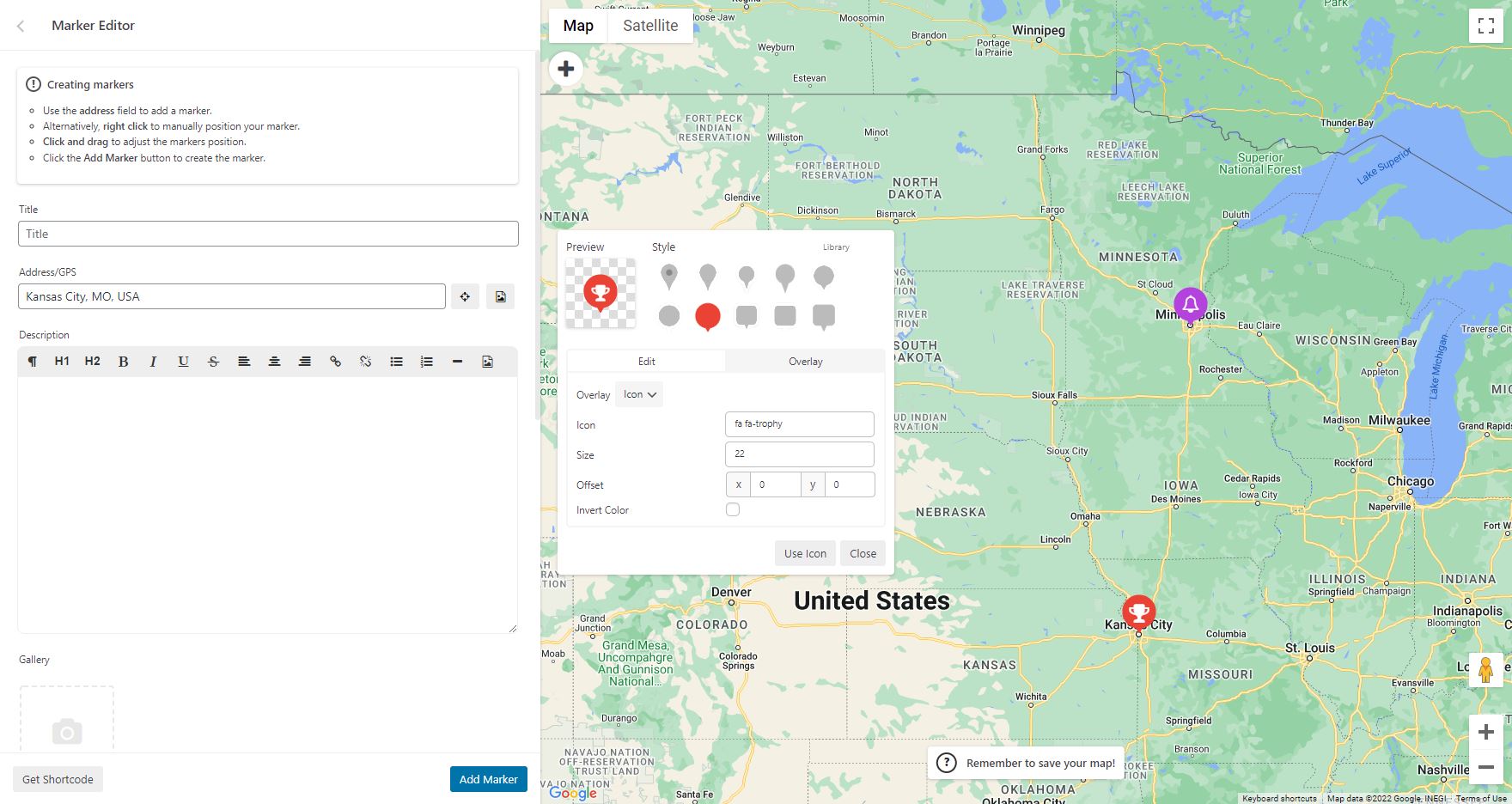
Erstelle deine erste Kartenmarkierung
Um eine Markierung zu deiner Google Karte hinzuzufügen, scrolle runter bis zu deinem Adminbereich und gebe GPS oder Adressdaten in das Adressfeld ein. Klicke dann auf „Markierung hinzufügen“ und WP Google Maps wird die Markierung an die von dir angegebene Adresse setzen.
Erstelle einen Google Maps Ladenfinder
Damit dein WP Google Maps Ladenfinder funktioniert, musst du einfach im Bereich „Ladenfinder“ auf den Bereich „Karte erstellen“ klicken und „Ja“ auswählen.
FAQ
-
Wie kann ich WP Google Maps Pro kaufen?
-
Besuche einfach https://www.wpgmaps.com und kaufe die WP Go Maps Professional Edition. Kostenlose Updates und Support für immer inklusive.
-
Ich habe das Plugin installiert. Was nun?
-
Einmal installiert und aktiviert, sollte in deinem linken Navigationsbereich ein Link zu deiner WP Administration erscheinen. Klicke auf diesen Link und befolge die Anweisungen auf dem Bildschirm.
-
Wie füge ich eine Google Map in meinen Eintrag oder meine Seite ein?
-
Um deine eigenen Google Karte in deinem Beitrag oder auf deiner Seite zu zeigen, kopiere einfach den automatisch erstellten Code und füge in auf dem entsprechenden Beitrag oder Seite ein. WP Google Maps wird die Karte automatisch und nach den von dir vorgenommenen Einstellungen erstellen.
-
Wie füge ich einen Kartenblock zu meiner Seite oder meinem Beitrag hinzu?
-
Es ist ganz einfach, deiner Seite oder deinem Beitrag einen Kartenblock hinzuzufügen. Füge einfach einen Block im normalen Seiteneditor hinzu und gib dann „Map“ ein, dann solltest du die Kartenblock-Option sehen. Weitere Informationen findest du in dieser Anleitung
-
Wie füge ich ein Kartenwidget in meinen Widgetbereich ein?
-
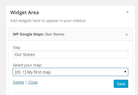
Um die Karte zu deinem Widgetsbereich hinzuzufügen, gehe einfach in „Erscheinung – Widget“ und ziehe das WP Google Maps Widget per Drag&Drop auf deine Seiteleiste. Danach musst du das Widget nur noch entsprechend bearbeiten um die korrekte Karte anzuzeigen.
-
Do I need a Google Maps API key?
-
Only if you choose Google Maps as your map engine. WP Go Maps also supports Leaflet, OpenLayers, Stadia Maps, Maptiler, LocationIQ, Microsoft Azure and a Zero Cost option, none of which require a Google API key. You can switch engines at any time from Maps > Settings.
-
Which map engine should I choose?
-
If you want Google’s native maps and have an API key, choose Google Maps. If you prefer an engine that does not require a billing-enabled API key, Leaflet (OpenStreetMap tiles) is a popular choice. OpenLayers, Stadia Maps, Maptiler, LocationIQ and Microsoft Azure are also supported. Zero Cost is a Leaflet-based option that requires no setup. Engine choice does not affect your stored markers, so you can switch later without losing data.
-
Why is my map not showing on the front-end?
-
First, confirm the shortcode or block is added to the page correctly. Then open your browser’s developer console and look for errors related to the map engine you are using. If you are using Google Maps, check that the API key in Maps > Settings is valid and is not restricted to a different domain. Theme or plugin conflicts are also common. For a full troubleshooting walkthrough see our troubleshooting documentation.
-
Is the plugin GDPR-compliant?
-
WP Go Maps does not set tracking cookies and does not transmit visitor data to third parties beyond the map tile and geocoding requests required to render the map. The plugin includes a built-in GDPR consent prompt that blocks those API requests until a visitor accepts. Configure it under Maps > Settings > GDPR.
-
How many markers can I add to a single map?
-
There is no hard limit. The free version supports as many markers as you need to add manually. The Pro version adds bulk CSV import, marker categories, marker clustering and batched loading for sites with thousands of markers.
-
Does the plugin work with Elementor, Divi, Gutenberg and other page builders?
-
Yes. WP Go Maps ships with a Gutenberg map block, an Elementor widget and a classic WordPress widget. The map shortcode works in any page builder that accepts WordPress shortcodes, including Divi, WPBakery, Beaver Builder and Oxygen.
-
Does the plugin support WPML, Polylang and multilingual sites?
-
The free version is translation-ready and ships with full translations for French, German, Italian, Spanish and Polish, plus partial coverage for many other languages. WP Go Maps Pro adds dynamic translation support for marker fields (title, description, address) via WPML.
-
Can I import markers from a CSV or spreadsheet?
-
Yes, with WP Go Maps Pro. The Pro version’s import tool accepts CSV, KML and KMZ files and supports batched imports for very large datasets. The free version supports manual marker entry only.
-
Is the plugin compatible with caching plugins and Cloudflare?
-
Yes. WP Go Maps works with all major caching plugins including WP Rocket, W3 Total Cache and LiteSpeed Cache, as well as Cloudflare. If the map stops loading after enabling aggressive optimisation (JS minification or deferral), exclude the wp-google-maps scripts from those rules and the map will render correctly.
-
Wie kann ich Sicherheitslücken melden?
-
Du kannst Sicherheitslücken über das Patchstack Vulnerability Disclosure Program melden. Das Patchstack-Team hilft bei der Überprüfung, Sichtung und Behandlung von Sicherheitslücken. Melde eine Sicherheitslücke.
Rezensionen
Mitwirkende und Entwickler
„WP Go Maps – Google Map, OpenStreetMap, Leaflet Map“ ist Open-Source-Software. Folgende Menschen haben an diesem Plugin mitgewirkt:
Mitwirkende„WP Go Maps – Google Map, OpenStreetMap, Leaflet Map“ wurde in 23 Sprachen übersetzt. Danke an die Übersetzer für ihre Mitwirkung.
Übersetze „WP Go Maps – Google Map, OpenStreetMap, Leaflet Map“ in deine Sprache.
Interessiert an der Entwicklung?
Durchstöbere den Code, sieh dir das SVN-Repository an oder abonniere das Entwicklungsprotokoll per RSS.
Änderungsprotokoll
10.1.03 – 2026-06-17
- Fixed issue where the internal engine assignment could be skipped on fresh installs, defaulting new installations to Atlas Major instead of the intended random assignment
10.1.02 – 2026-06-15
- Fixed issue where unauthenticated requests could trigger unintended database writes via the DataTables REST endpoint. Security issue, thanks to Thanh Diem (Wordfence)
- Fixed issue where Datatables language files may not load correctly in some environments due to name case. Fallback system developed to resolve and fail gracefully if unavailable
10.1.01 – 2026-06-10
- Added a canonical POT translation template (languages/wp-google-maps.pot) so translators and contributors can generate and maintain language files from a single source rather than reconstructing the template locally each pass
- Added a fully complete French (fr_FR) translation, refreshed against the 10.1.00 codebase including all Atlas Major UI strings.
- Added a fully complete German (de_DE) translation, refreshed against the 10.1.00 codebase including all Atlas Major UI strings.
- Added a fully complete Italian (it_IT) translation, refreshed against the 10.1.00 codebase including all Atlas Major UI strings.
- Added a fully complete Spanish (es_ES) translation, refreshed against the 10.1.00 codebase including all Atlas Major UI strings.
- Added a fully complete Polish (pl_PL) translation, refreshed against the 10.1.00 codebase including all Atlas Major UI strings.
- Improved responsiveness of the map editor at narrow viewports (Atlas Major).
- Fixed issue where Leaflet frontend maps could place markers at incorrect pixel positions when the page layout had not finished settling at map construction time. An invalidateSize() call after first paint forces the origin to be recalculated against the correct container dimensions
10.1.00 – 2026-06-03
- Added Atlas Major, a new editor UI.
- Added live preview to the map editor, showing how the page will render with real-time updates as settings change (Atlas Major)
- Added automatic background save via REST. Form changes are persisted shortly after a change with a „Saved“ indicator, falling back to a native form submit after 3 seconds if the REST request fails (Atlas Major)
- Added live tileset swap, applying a tileset to the editor map immediately on selection without needing to save (Atlas Major)
- Added click-drag isolation on info-window panels, directions boxes, and inner-stack overlays so panel interactions no longer drag the map underneath (Atlas Major)
- Added „Save & Reload“ confirmation modal for settings that require a fresh map construction, with an in-progress overlay during the reload (Atlas Major)
- Added auto-scroll to top and address field focus after a successful Add Marker (Atlas Major)
- Added auto-close of info window panel after delete, and auto-refresh of info window content after a marker save (Atlas Major)
- Added store locator text override preservation across editor rebuilds (Atlas Major)
- Added 🔑 indicator next to engines in the engine switch dropdown that require an API key
- Added missing API key notice for Microsoft Azure, Stadia Maps, Maptiler, and LocationIQ. Previously only Google Maps would surface this notice
- Added auto-return to the feature list panel after a successful Add Marker or Add shape
- Fixed issue where saving the map in basic would write empty strings into Pro-only store locator visual fields, leading to invisible store locator circles after Pro was activated
- Fixed issue where info-window distance calculation read the wrong unit source, causing „miles away“ labels to render kilometre values
- Fixed issue where the map list page displayed poorly on small screens due to DataTables 2 colgroup widths
- Fixed issue where the map editor REST autosave returned a 500 error under Pro because an admin-only file include was not available in the REST request context
- Fixed issue where the Plugin class __isset method was missing magic-getter cases, causing several live preview Pro template injections to silently fail (Atlas Major)
- Fixed issue where the custom image overlay live preview could corrupt the map start coordinates because the Leaflet CRS is locked at map construction (Atlas Major)
- Fixed issue where unchecked checkboxes were treated as enabled in live preview (Atlas Major)
- Fixed issue where the action bar Save Map and Preview buttons would wrap to separate rows on narrow sidebars (Atlas Major)
- Fixed issue where the bulk markers REST endpoint would return unapproved markers to unauthenticated users. Security issue, thanks to Fraudless.tech (Ilyess Ghalem)
- Improved default map height for new maps from 400px to 600px
- Improved Save Map button feedback to pulse red with a spinner during autosave and manual saves (Atlas Major)
- Improved engine switching from the editor toolbar to reload the editor so the new engine libraries load correctly
- Improved missing API key notice to render as a centered card over the map area
- Improved store locator radius circle cleanup when components rebuild in live preview (Atlas Major)
- Improved editor diagnostics by removing verbose console output on page load and save (Atlas Major)
- Improved internationalisation by auditing UI strings and migrating hardcoded text to WPGMZA.localized_strings (Atlas Major)
- Improved cursor handling across editor panels and info-window overlays so Leaflet’s grab cursor no longer leaks into UI surfaces (Atlas Major)
10.0.10 – 2026-05-13
- Fixed issue where Datatables AJAX fallback would bypass the approval filter. Security issue, thanks to WPScan, Jetpack, Automattic (Erwan)
- Fixed issue where single marker endpoint and AJAX fallback would bypass the approval filter. Security issue, thanks to WPScan, Jetpack, Automattic (Erwan)
- Fixed issue where Pro users below V10.0.06 would experience issues with admin marker tables, which do not have access to V2 library methods
- Fixed issue where Pro users below V10.0.06 would experience issues Google Drawing Manager, which is being deprecated in favor of an internal module
- Fixed issue where WPML users would experience failure in the settings area when running legacy UI
10.0.09 – 2026-04-16
- Fixed issue where minified code base was not accurately compiled due to issue with internal build tools. Only affected pro users
10.0.08 – 2026-04-16
- Fixed issue where users on Pro below V10 would experience a DataTables V2 init failure, preventing access to the map editor and marker list. When Pro below V10 is detected, DataTables V1.12 and its Responsive extension are now loaded from CDN instead
- Fixed issue where users on Pro below V10 would see an init failure on the map editor due to the Google Drawing Manager library not being loaded. The drawing library is now injected into the Google Maps API URL via the compatibility layer when Pro below V10 is detected on the map edit page
10.0.07 – 2026-04-15
- Added methods to internal Google Drawing Manager, internalizing this feature, and allowing removal of native Google Drawing Manager. Due to upcoming deprecation
- Added scale line control support for Google Maps, Leaflet, and OpenLayers. Can be enabled on a per map basis
- Added ability to override plugin language from within the settings. Defaults to site language
- Added ability to override custom tile server token field name
- Added ability to override custom tile server type (raster or vector)
- Added native Elementor integration with Map and Store Locator widgets, mirroring the existing Gutenberg block structure
- Added ElementorModuleWidget abstract base class to provide a shared preview/render pattern for all Elementor module widgets
- Added support for WPML post type translations, ensuring integrated post type marker sources respect the active language
- Added blueprint JSON file to assets for preview mode support moving forward
- Fixed issue where script loader would throw a notice for Google vertex menu when not using Google Maps engine
- Fixed issue where Leaflet maps set to a starting zoom below 2 would cause incorrect marker placement due to EPSG3857 world-copy wrapping; a safe minZoom floor of 2 is now enforced for standard tile maps (custom tile/CRS.Simple maps are unaffected)
- Fixed issue where Astra Theme Compatibility layer may trigger an error on some environments
- Improved the language loader to ensure we don’t unexpectedly trigger a global language file due to missing files, as this leads to outdated translations
- Improved all datatables related styles to better support the V2 upgrade
- Updated FR translation files. Thanks to Madevcomfr
- Updated credits page to include new contributors and translators
- Updated internal process to ensure accurate version management (SVN)
- Updated DataTables to V2 release, and migrated core modules to support this change
- Updated WritersBlock internal library to add additional features
- Remove responsive DataTables extension as this is bundled in our V2 files
- Removed Google Drawing Manager as a dependency, in favour of internal module, which is being deprecated by Google
10.0.06 – 2026-03-17
- Fixed issue where nonce refresh actions were missing permission checks, creating an XSS vulnerability. Security issue. Thanks Nguyen Ba Hung (bashu) (KCSC) (Wordfence)
- Fixed issue where settings storage would rely purely on nonce checks, without reasserting permissions. Security issue. Thanks Nguyen Ba Hung (bashu) (KCSC) (Wordfence)
- Fixed issue where Google marker click event for AdvancedMarkerRender mode was set to ‚click‘ instead of the suggested ‚gmp-click‘
- Fixed issue where marker offset method would fail in Leaflet causing issues with NVC systems and other marker nudge modules
10.0.05 – 2026-01-14
- Fixed issue where notice actions were missing permission checks. Low level users could trigger actions like switching map engines. Security issue. Thanks Moose Love (Nagasaki Prefectural University) (Wordfence)
- Fixed issue where deferred loading with WP Rocket would lead to initialization error. We now exclude inline initializer and settings object from this system. Can be disabled in settings
- Fixed issue where batch marker loading would incorrectly trigger final shape fetch request
- Fixed issue where internal map library loaders would not respect force-load flag when enqueueing scripts
- Fixed issue with setMap calls on point labels
- Improved point label architecture to support regeneration and map ID changes if needed
10.0.04 – 2025-12-04
- Added pro features page and menu item
- Added additional page construction hooks
- Added demo list to maps view page
- Added LocationIQ to engine swap toolbar
- Improved PHP 8.5 stability & compatibility
- Fixed issue where engine swap toolbar would not set tileserver defaults for first time users
- Fixed issue where map list clicks were not being handled correctly for action buttons
- Fixed issue where PHP 8.5 would throw a deprecation warning due to an outdated switch case
- Fixed issue with our internal links, docs, site, support, forums, throughout the plugin
- Fixed issue where bulk marker selection button would not work in some environments
- Fixed issue where info-window link controls were available in basic
- Updated marker listing demo image
10.0.03 – 2025-11-27
- Added first time usage flow which opens the marker creator once for new users (UX Improvement)
- Added engine swap toolbar to map editor for first time usage, once dismissed does not show again (UX Improvement)
- Added a new setting to enable dynamic translations, as this must be an opt in for large data sites
- Updated internal CTA buttons and controls from gold to blue (UX Improvement)
- Removed a console log within the map initialization controller, it is not relevant with delayed loading
- Removed the disable dynamic translation, instead we now allow this via an opt in instead
10.0.02 – 2025-11-17
- Added shapes and overlays sub-section to map editor, moving all relevant datasets into that panel (UX Improvement)
- Added ability to click on a map from the map list to open the editor (UX Improvement)
- Added primary button color to edit map button within map list (UX Improvement)
- Added blue highlight to primary dataset creation buttons to make it clearer how to add datasets (UX Improvement)
- Added button to marker quick tip notice to jump straight to marker creation (UX Improvement)
- Added conditional checks for major version mismatches in compiler, preventing mismatched major versions from throwing build errors
- Added a one time hint tool to our internal map editor tour system, which will show helpful usage hints after the main tour is completed.
- Fixed issue where Google Maps logo would not display on some installations, within the engine selector
- Fixed issue where plugins that load bootstrap in our editor might cause editor placement issues, plugin conflict
- Fixed issue where map preview would not generate on some themes. We now generate a draft page, which is reused and pruned when new previews are created
- Moved save map notice in map editor to top anchor
- Moved add marker quick tip notice in map editor to bottom left anchor
- Removed bounds reset system when adding a marker to a map, to allow multiple markers to be added to the same region without reset
10.0.01 – 2025-11-10
- Fixed issue with compatibility layer for older versions of Pro add-on (V8 and below)
10.0.00 – 2025-11-10
- Added Leaflet engine support
- Added Azure engine, powered by Leaflet
- Added Stadia engine, powered by Leaflet
- Added Maptiler engine, powered by Leaflet
- Added LocationIQ engine, powered by Leaflet
- Added support for OpenLayers V10
- Added ability to use legacy (V6) OpenLayers, should be considered deprecated. Will be removed in the future
- Added ability to change address providers, for autocomplete and client side geocoding
- Added additional address providers including Google Maps, Azure Maps, Nominatim, LocationIQ and engine default
- Added ability to provide a supplementary address provider API key if needed
- Added ability to switch tile servers, with another from the same provider, on a per map basis
- Added additional tile server options, with providers and automated groupings
- Added ability to set line thickness on both rectangles and circles
- Added tile server previews for improved customization
- Added support for dynamic content translations with WPML
- Added Atlas Novus as the default internal build
- Added danger zone tool to reindex any spatial coordinate data for markers, where a spatial coordinate has gone missing
- Added ability to adjust rectangle boundaries with boundary input
- Added ability to bulk delete shapes
- Added ability to center on shapes and datasets within the editor
- Added dropdown context meny to shape datatables
- Added option to cachebust REST API requests
- Added improved GDPR styling, it becomes the new default
- Added quick delete button to info-window within the map editor
- Added ability to override any HTML template part via a child theme override
- Added map preview system, allowing maps to be previewed on frontpage
- Added default indexes to all tables to improve performance
- Added spatial indexes to tables where applicable to improve performance
- Added fullscreen map editor panel mode, for dataset listings, allowing more data to be viewed
- Added extended maximum zoom level (22) which is supported by all map engines
- Added mobile settings tab to editor
- Added ability to set a different map width/height for mobile devices
- Added new default engine/installer preset for zero cost mapping, for all new installations
- Added ability to reduce marker editor geocoder usage. Skips geocoding if lat/lng coordinates are present, opt in available in settings
- Added ability to select store locator button style (Icons (default), or Text) on a per map basis
- Added accessibility support, with the goal of being WCAG Level AA compliant
-
- Aria labels and roles added where needed
-
- Improved focus cues and managing of indexing
-
- Keyboard navigation added (tab, enter, space, and escape for panels)
-
- Hierarchy restructuring where needed to better support navigation
-
- Tested with various tools:
-
-
- Microsoft Accessibility Insights: Pass (FastPass)
-
-
-
- Axe DevTools: Pass (WCAG Level AA)
-
-
-
- Google Lighthouse: Pass (100% Accessible)
-
-
-
- Wave Tools: Pass
-
-
- Manual testing completed for navigation with a keyboard
-
- We will continue to improve this over time
-
- Known Issues
-
-
- Only supported on the frontend
-
-
-
- Does not allow marker selection via the map container (Marker listings supported, and encouraged for accessibility focused installations)
-
-
-
- Although a substantial rework has been implemented, this has not been verified by 3rd party compliance testers at this stage
-
-
-
-
- We know that accessibility is more nuanced than simple machine driven tests, we’d like to work with our community to ensure we improve this further
-
-
-
-
-
- Please reach out to us if you find anything that you feel should be improved as a priority!
-
-
- Improved internal autocomplete modules for better user experience and management
- Improved theme preset user interface
- Improved theme CSS editor
- Improved tile server system to handle params and authentication more efficiently
- Improved tile server system to properly attribute various service providers
- Improved settings user interface, adding sections and descriptors for better clarity
- Improved Google Maps Advanced Marker render mode support
- Improved Google Async support
- Improved zoom sliders within editor
- Improved map initialization state control
- Improved map initialization error correction
- Improved map initialization automatic delayed retry module
- Improved info-window open calls to include data-props in container for styling
- Improved styling system to allow native info-windows to inherit brand styling
- Improved open layers native info-window, now includes border radius and shadows
- Improved checkbox styling within the map viewport
- Improved available WP filters within our AjaxTable class, allowing count values to be filtered
- Improved internal shape architecture
- Improved batch loader logic and modularized method
- Improved welcome page to include new features
- Improved all option management by disabling autoloading, reducing impact on server resources
- Improved Legacy to Atlas Novus migration flow by introducing automatic map settings migration modules
- Improved DomDocument param handlers where needed
- Fixed issue where marker labels would not render & symbols correctly
- Fixed issue where major version mismatch would cause UI error to be thrown in REST API requests
- Fixed issue where shape datatables within the editor couldn’t be searched fully
- Fixed issue where touch events would not dispatch on OpenLayers shapes
- Fixed issue with error suppression in DomDocument class, added LIBXML_NOERROR when
- Fixed issue where some overlays would overlap info-windows in Open Layers (Example clusters)
- Fixed issue with clustering translations in DE language files
- Fixed issue where engine switch notice would show even if the user has already switched to Atlas Novus (manually)
- Moved build selection Danger Zone
- Moved optimization options out of beta
- Moved map mobile zoom level control to mobile panel section
- Removed Stamen Design tile servers, as they have moved to Stadia
- Removed OpenPtMap tile server due to missing SSL
- Removed duplicate map fetch methods, which were unused
- Archived V9 changelogs
For more, please view the WP Go Maps site.